|
|
|||||||||||||||||
| Point ID: 9368 | Downloads | Plots | Site Data | Code: 15302500 |
|
|
|||||||||||||||||
| Download | |
|---|---|
| Site Descriptor Information | Site Time Series Data |
| Link to all available data | |
|
|
| View: | Statistics | Time Series |
| Units: | mm |
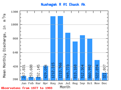
| Statistic | Jan | Feb | Mar | Apr | May | Jun | Jul | Aug | Sep | Oct | Nov | Dec | Annual |
|---|---|---|---|---|---|---|---|---|---|---|---|---|---|
| Mean | 267.83 | 253.69 | 252.15 | 429.09 | 1212.32 | 1213.97 | 949.77 | 813.17 | 912.30 | 860.99 | 522.89 | 321.81 | 663.47 |
| Standard Deviation | 58.56 | 57.53 | 57.99 | 219.15 | 408.17 | 295.63 | 259.73 | 191.59 | 346.92 | 288.53 | 196.80 | 91.86 | 109.50 |
| Min | 181.96 | 173.95 | 166.98 | 162.35 | 591.55 | 687.91 | 616.67 | 498.93 | 372.93 | 386.85 | 262.21 | 183.33 | 441.03 |
| Max | 373.60 | 368.12 | 348.02 | 885.85 | 1973.96 | 1666.07 | 1492.57 | 1111.03 | 1687.40 | 1388.35 | 1024.60 | 458.55 | 846.24 |
| Coefficient of Variation | 0.22 | 0.23 | 0.23 | 0.51 | 0.34 | 0.24 | 0.27 | 0.24 | 0.38 | 0.34 | 0.38 | 0.28 | 0.17 |
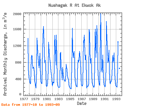
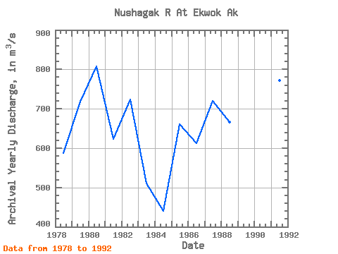
| Year | Jan | Feb | Mar | Apr | May | Jun | Jul | Aug | Sep | Oct | Nov | Dec | Annual | 1977 | 1376.93 | 642.79 | 441.19 | 1978 | 373.60 | 318.56 | 280.43 | 298.18 | 915.27 | 972.68 | 933.91 | 655.67 | 670.35 | 683.17 | 576.34 | 363.55 | 586.81 | 1979 | 293.95 | 201.25 | 183.60 | 620.04 | 1389.08 | 1175.62 | 875.45 | 857.45 | 671.68 | 888.51 | 1024.60 | 442.11 | 718.61 | 1980 | 337.98 | 300.74 | 292.30 | 712.64 | 1440.51 | 1666.07 | 1492.57 | 1060.60 | 795.89 | 846.40 | 505.93 | 241.15 | 807.73 | 1981 | 215.39 | 245.95 | 322.45 | 593.43 | 1288.87 | 1072.93 | 861.93 | 857.09 | 668.47 | 587.16 | 479.03 | 283.99 | 623.06 | 1982 | 235.76 | 323.82 | 314.68 | 305.44 | 1205.57 | 1454.92 | 1103.35 | 734.68 | 1457.94 | 959.67 | 343.11 | 235.85 | 722.90 | 1983 | 205.89 | 198.22 | 195.66 | 210.68 | 1003.79 | 1039.51 | 692.12 | 571.91 | 372.93 | 675.95 | 502.15 | 458.55 | 510.61 | 1984 | 368.12 | 368.12 | 339.80 | 362.45 | 754.96 | 687.91 | 635.21 | 498.93 | 415.88 | 386.85 | 262.21 | 211.92 | 441.03 | 1985 | 181.96 | 173.95 | 166.98 | 162.35 | 681.71 | 1627.18 | 1064.07 | 1024.07 | 912.75 | 1065.81 | 497.90 | 363.55 | 660.19 | 1986 | 278.33 | 231.39 | 220.14 | 212.38 | 591.55 | 859.23 | 815.80 | 861.01 | 1063.49 | 1002.69 | 782.21 | 424.75 | 611.91 | 1987 | 262.25 | 232.81 | 231.28 | 298.08 | 1319.38 | 1274.82 | 1457.22 | 1054.48 | 862.91 | 974.92 | 492.05 | 183.33 | 720.29 | 1988 | 224.25 | 226.53 | 228.00 | 285.06 | 1592.96 | 1498.53 | 1044.62 | 786.66 | 900.38 | 617.49 | 329.42 | 264.90 | 666.57 | 1989 | 238.87 | 212.38 | 196.94 | 240.69 | 1461.88 | 1603.58 | 924.50 | 1111.03 | 1687.40 | 1388.35 | 683.66 | 405.57 | 846.24 | 1990 | 325.19 | 269.01 | 249.83 | 885.85 | 1973.96 | 1114.17 | 616.67 | 562.68 | 975.61 | 707.10 | 343.58 | 266.27 | 690.83 | 1991 | 232.47 | 212.88 | 257.13 | 649.40 | 1785.97 | 1373.08 | 1141.99 | 789.31 | 838.37 | 1094.13 | 581.82 | 311.49 | 772.34 | 1992 | 286.37 | 331.01 | 348.02 | 394.55 | 695.41 | 961.17 | 807.49 | 932.17 | 1027.52 | 520.76 | 319.51 | 250.74 | 572.89 | 1993 | 224.94 | 212.38 | 207.08 | 634.30 | 1296.18 | 1042.06 | 729.48 | 652.93 | 1275.30 |
|---|
 Return to R-Arctic Net Home Page