|
|
|||||||||||||||||
| Point ID: 9339 | Downloads | Plots | Site Data | Code: 15303010 |
|
|
|||||||||||||||||
| Download | |
|---|---|
| Site Descriptor Information | Site Time Series Data |
| Link to all available data | |
|
|
| View: | Statistics | Time Series |
| Units: | mm |
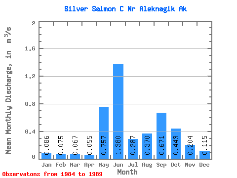
| Statistic | Jan | Feb | Mar | Apr | May | Jun | Jul | Aug | Sep | Oct | Nov | Dec | Annual |
|---|---|---|---|---|---|---|---|---|---|---|---|---|---|
| Mean | 0.09 | 0.07 | 0.07 | 0.06 | 0.76 | 1.38 | 0.29 | 0.37 | 0.67 | 0.44 | 0.20 | 0.12 | 0.44 |
| Standard Deviation | 0.04 | 0.01 | 0.01 | 0.00 | 0.59 | 0.59 | 0.07 | 0.17 | 0.37 | 0.32 | 0.22 | 0.10 | |
| Min | 0.06 | 0.07 | 0.06 | 0.05 | 0.27 | 0.65 | 0.21 | 0.18 | 0.44 | 0.14 | 0.05 | 0.04 | 0.44 |
| Max | 0.12 | 0.08 | 0.07 | 0.06 | 1.42 | 2.00 | 0.39 | 0.51 | 1.22 | 0.88 | 0.36 | 0.19 | 0.44 |
| Coefficient of Variation | 0.48 | 0.08 | 0.08 | 0.08 | 0.78 | 0.43 | 0.26 | 0.47 | 0.55 | 0.71 | 1.10 | 0.90 |
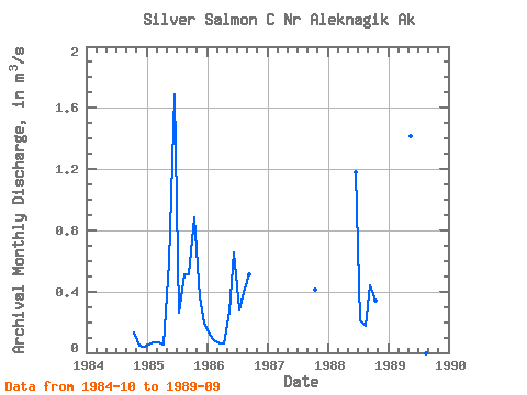
| Year | Jan | Feb | Mar | Apr | May | Jun | Jul | Aug | Sep | Oct | Nov | Dec | Annual | 1984 | 0.14 | 0.05 | 0.04 | 1985 | 0.06 | 0.07 | 0.07 | 0.05 | 0.59 | 1.69 | 0.27 | 0.51 | 0.51 | 0.88 | 0.36 | 0.19 | 0.44 | 1986 | 0.12 | 0.08 | 0.06 | 0.06 | 0.27 | 0.65 | 0.28 | 0.42 | 0.51 | 1987 | 0.41 | 1988 | 1.18 | 0.21 | 0.18 | 0.44 | 0.34 | 1989 | 1.42 | 2.00 | 0.39 | 1.22 |
|---|
 Return to R-Arctic Net Home Page