|
|
|||||||||||||||||
| Point ID: 9332 | Downloads | Plots | Site Data | Code: 15054600 |
|
|
|||||||||||||||||
| Download | |
|---|---|
| Site Descriptor Information | Site Time Series Data |
| Link to all available data | |
|
|
| View: | Statistics | Time Series |
| Units: | mm |
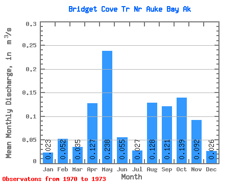
| Statistic | Jan | Feb | Mar | Apr | May | Jun | Jul | Aug | Sep | Oct | Nov | Dec | Annual |
|---|---|---|---|---|---|---|---|---|---|---|---|---|---|
| Mean | 0.02 | 0.05 | 0.04 | 0.13 | 0.24 | 0.06 | 0.03 | 0.13 | 0.12 | 0.14 | 0.09 | 0.03 | 0.09 |
| Standard Deviation | 0.01 | 0.05 | 0.01 | 0.05 | 0.10 | 0.02 | 0.01 | 0.03 | 0.02 | 0.06 | 0.02 | 0.01 | 0.01 |
| Min | 0.01 | 0.01 | 0.03 | 0.07 | 0.18 | 0.04 | 0.02 | 0.10 | 0.10 | 0.07 | 0.07 | 0.02 | 0.08 |
| Max | 0.04 | 0.11 | 0.05 | 0.16 | 0.35 | 0.08 | 0.04 | 0.16 | 0.14 | 0.18 | 0.11 | 0.04 | 0.10 |
| Coefficient of Variation | 0.55 | 1.02 | 0.31 | 0.41 | 0.40 | 0.35 | 0.36 | 0.26 | 0.19 | 0.41 | 0.23 | 0.35 | 0.10 |
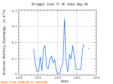
| Year | Jan | Feb | Mar | Apr | May | Jun | Jul | Aug | Sep | Oct | Nov | Dec | Annual | 1970 | 0.16 | 0.07 | 0.02 | 1971 | 0.02 | 0.11 | 0.03 | 0.16 | 0.18 | 0.05 | 0.04 | 0.10 | 0.12 | 0.07 | 0.09 | 0.02 | 0.08 | 1972 | 0.01 | 0.01 | 0.05 | 0.07 | 0.35 | 0.08 | 0.02 | 0.13 | 0.10 | 0.18 | 0.11 | 0.04 | 0.10 | 1973 | 0.04 | 0.04 | 0.04 | 0.15 | 0.18 | 0.04 | 0.02 | 0.16 | 0.14 |
|---|
 Return to R-Arctic Net Home Page