|
|
|||||||||||||||||
| Point ID: 9321 | Downloads | Plots | Site Data | Code: 15057580 |
|
|
|||||||||||||||||
| Download | |
|---|---|
| Site Descriptor Information | Site Time Series Data |
| Link to all available data | |
|
|
| View: | Statistics | Time Series |
| Units: | mm |
| Statistic | Jan | Feb | Mar | Apr | May | Jun | Jul | Aug | Sep | Oct | Nov | Dec | Annual |
|---|---|---|---|---|---|---|---|---|---|---|---|---|---|
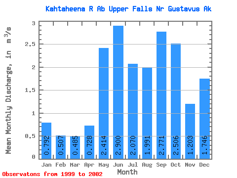
| Mean | 0.79 | 0.51 | 0.48 | 0.73 | 2.41 | 2.90 | 2.07 | 1.99 | 2.77 | 2.51 | 1.20 | 1.75 | 1.48 |
| Standard Deviation | 0.32 | 0.18 | 0.21 | 0.32 | 0.71 | 0.33 | 0.29 | 1.25 | 0.63 | 0.80 | 0.49 | 1.64 | 0.25 |
| Min | 0.53 | 0.31 | 0.25 | 0.43 | 1.64 | 2.56 | 1.74 | 0.76 | 2.19 | 1.92 | 0.65 | 0.58 | 1.30 |
| Max | 1.14 | 0.66 | 0.64 | 1.07 | 3.04 | 3.23 | 2.24 | 3.72 | 3.62 | 3.42 | 1.56 | 3.62 | 1.65 |
| Coefficient of Variation | 0.40 | 0.35 | 0.43 | 0.44 | 0.29 | 0.12 | 0.14 | 0.62 | 0.23 | 0.32 | 0.41 | 0.94 | 0.17 |
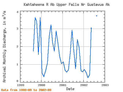
| Year | Jan | Feb | Mar | Apr | May | Jun | Jul | Aug | Sep | Oct | Nov | Dec | Annual | 1999 | 1.74 | 3.62 | 3.42 | 1.56 | 3.62 | 2000 | 0.53 | 0.31 | 0.64 | 1.07 | 2.57 | 3.23 | 2.24 | 1.75 | 2.88 | 2.18 | 1.41 | 1.04 | 1.65 | 2001 | 1.14 | 0.66 | 0.56 | 0.68 | 1.64 | 2.92 | 1.74 | 0.76 | 2.39 | 1.92 | 0.65 | 0.58 | 1.30 | 2002 | 0.70 | 0.55 | 0.25 | 0.43 | 3.04 | 2.56 | 2.23 | 3.72 | 2.19 |
|---|
 Return to R-Arctic Net Home Page