|
|
|||||||||||||||||
| Point ID: 9313 | Downloads | Plots | Site Data | Code: 15056070 |
|
|
|||||||||||||||||
| Download | |
|---|---|
| Site Descriptor Information | Site Time Series Data |
| Link to all available data | |
|
|
| View: | Statistics | Time Series |
| Units: | mm |
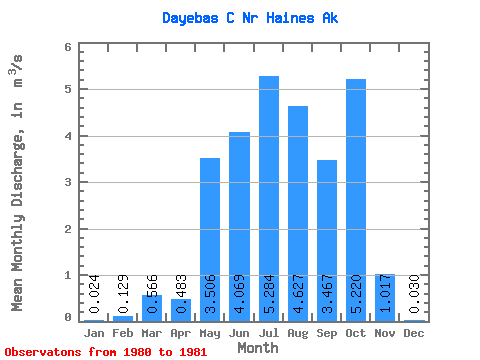
| Statistic | Jan | Feb | Mar | Apr | May | Jun | Jul | Aug | Sep | Oct | Nov | Dec | Annual |
|---|---|---|---|---|---|---|---|---|---|---|---|---|---|
| Mean | 0.02 | 0.13 | 0.57 | 0.48 | 3.51 | 4.07 | 5.28 | 4.63 | 3.47 | 5.22 | 1.02 | 0.03 | |
| Standard Deviation | 0.05 | 0.24 | 0.25 | 0.99 | |||||||||
| Min | 0.02 | 0.13 | 0.57 | 0.48 | 3.51 | 4.03 | 5.12 | 4.45 | 2.77 | 5.22 | 1.02 | 0.03 | |
| Max | 0.02 | 0.13 | 0.57 | 0.48 | 3.51 | 4.11 | 5.45 | 4.80 | 4.17 | 5.22 | 1.02 | 0.03 | |
| Coefficient of Variation | 0.01 | 0.04 | 0.05 | 0.29 |
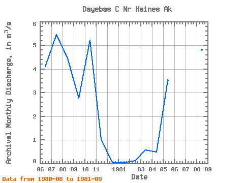
| Year | Jan | Feb | Mar | Apr | May | Jun | Jul | Aug | Sep | Oct | Nov | Dec | Annual | 1980 | 4.11 | 5.45 | 4.45 | 2.77 | 5.22 | 1.02 | 0.03 | 1981 | 0.02 | 0.13 | 0.57 | 0.48 | 3.51 | 4.03 | 5.12 | 4.80 | 4.17 |
|---|
 Return to R-Arctic Net Home Page