|
|
|||||||||||||||||
| Point ID: 9308 | Downloads | Plots | Site Data | Code: 15081614 |
|
|
|||||||||||||||||
| Download | |
|---|---|
| Site Descriptor Information | Site Time Series Data |
| Link to all available data | |
|
|
| View: | Statistics | Time Series |
| Units: | mm |
| Statistic | Jan | Feb | Mar | Apr | May | Jun | Jul | Aug | Sep | Oct | Nov | Dec | Annual |
|---|---|---|---|---|---|---|---|---|---|---|---|---|---|
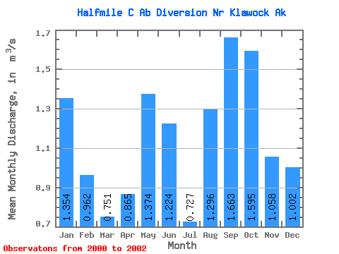
| Mean | 1.35 | 0.96 | 0.75 | 0.86 | 1.37 | 1.22 | 0.73 | 1.30 | 1.66 | 1.59 | 1.06 | 1.00 | 1.32 |
| Standard Deviation | 0.46 | 0.26 | 0.53 | 0.24 | 0.46 | 1.04 | 0.27 | 0.62 | 0.14 | 0.46 | |||
| Min | 1.03 | 0.78 | 0.38 | 0.70 | 1.05 | 0.48 | 0.54 | 0.86 | 1.56 | 1.59 | 1.06 | 0.68 | 1.32 |
| Max | 1.68 | 1.15 | 1.12 | 1.03 | 1.70 | 1.96 | 0.92 | 1.73 | 1.76 | 1.59 | 1.06 | 1.33 | 1.32 |
| Coefficient of Variation | 0.34 | 0.27 | 0.70 | 0.28 | 0.33 | 0.85 | 0.37 | 0.48 | 0.08 | 0.46 |
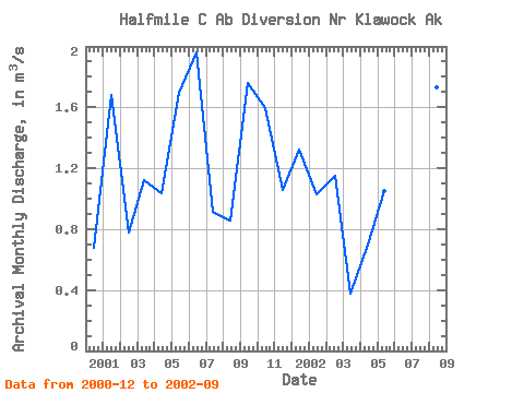
| Year | Jan | Feb | Mar | Apr | May | Jun | Jul | Aug | Sep | Oct | Nov | Dec | Annual | 2000 | 0.68 | 2001 | 1.68 | 0.78 | 1.12 | 1.03 | 1.70 | 1.96 | 0.92 | 0.86 | 1.76 | 1.59 | 1.06 | 1.33 | 1.32 | 2002 | 1.03 | 1.15 | 0.38 | 0.70 | 1.05 | 0.48 | 0.54 | 1.73 | 1.56 |
|---|
 Return to R-Arctic Net Home Page