|
|
|||||||||||||||||
| Point ID: 9296 | Downloads | Plots | Site Data | Code: 15081620 |
|
|
|||||||||||||||||
| Download | |
|---|---|
| Site Descriptor Information | Site Time Series Data |
| Link to all available data | |
|
|
| View: | Statistics | Time Series |
| Units: | mm |
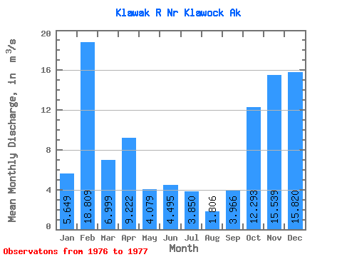
| Statistic | Jan | Feb | Mar | Apr | May | Jun | Jul | Aug | Sep | Oct | Nov | Dec | Annual |
|---|---|---|---|---|---|---|---|---|---|---|---|---|---|
| Mean | 5.65 | 18.81 | 7.00 | 9.22 | 4.08 | 4.50 | 3.85 | 1.81 | 3.97 | 12.29 | 15.54 | 15.82 | |
| Standard Deviation | |||||||||||||
| Min | 5.65 | 18.81 | 7.00 | 9.22 | 4.08 | 4.50 | 3.85 | 1.81 | 3.97 | 12.29 | 15.54 | 15.82 | |
| Max | 5.65 | 18.81 | 7.00 | 9.22 | 4.08 | 4.50 | 3.85 | 1.81 | 3.97 | 12.29 | 15.54 | 15.82 | |
| Coefficient of Variation |
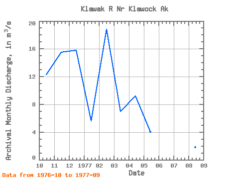
| Year | Jan | Feb | Mar | Apr | May | Jun | Jul | Aug | Sep | Oct | Nov | Dec | Annual | 1976 | 12.29 | 15.54 | 15.82 | 1977 | 5.65 | 18.81 | 7.00 | 9.22 | 4.08 | 4.50 | 3.85 | 1.81 | 3.97 |
|---|
 Return to R-Arctic Net Home Page