|
|
|||||||||||||||||
| Point ID: 9273 | Downloads | Plots | Site Data | Code: 15054990 |
|
|
|||||||||||||||||
| Download | |
|---|---|
| Site Descriptor Information | Site Time Series Data |
| Link to all available data | |
|
|
| View: | Statistics | Time Series |
| Units: | mm |
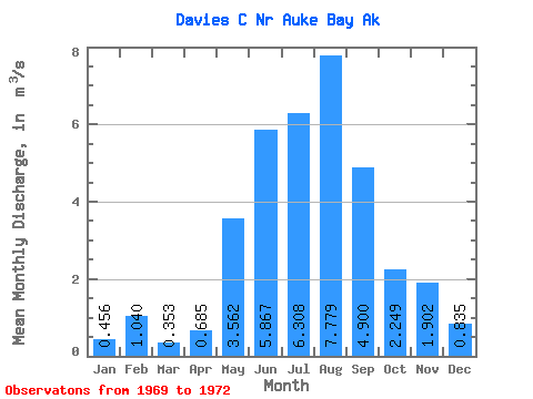
| Statistic | Jan | Feb | Mar | Apr | May | Jun | Jul | Aug | Sep | Oct | Nov | Dec | Annual |
|---|---|---|---|---|---|---|---|---|---|---|---|---|---|
| Mean | 0.46 | 1.04 | 0.35 | 0.69 | 3.56 | 5.87 | 6.31 | 7.78 | 4.90 | 2.25 | 1.90 | 0.83 | 2.68 |
| Standard Deviation | 0.25 | 0.84 | 0.28 | 0.28 | 1.62 | 0.46 | 0.92 | 2.04 | 0.14 | 1.11 | 1.30 | 0.82 | 0.00 |
| Min | 0.17 | 0.10 | 0.12 | 0.38 | 2.53 | 5.56 | 5.54 | 5.84 | 4.80 | 1.36 | 0.85 | 0.33 | 2.68 |
| Max | 0.64 | 1.72 | 0.66 | 0.92 | 5.43 | 6.40 | 7.33 | 9.92 | 5.06 | 3.49 | 3.36 | 1.79 | 2.68 |
| Coefficient of Variation | 0.55 | 0.81 | 0.79 | 0.40 | 0.45 | 0.08 | 0.15 | 0.26 | 0.03 | 0.49 | 0.69 | 0.99 | 0.00 |
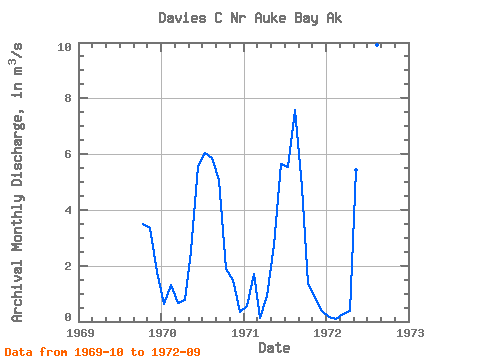
| Year | Jan | Feb | Mar | Apr | May | Jun | Jul | Aug | Sep | Oct | Nov | Dec | Annual | 1969 | 3.49 | 3.36 | 1.79 | 1970 | 0.64 | 1.31 | 0.66 | 0.76 | 2.53 | 5.56 | 6.05 | 5.84 | 5.06 | 1.90 | 1.49 | 0.33 | 2.68 | 1971 | 0.56 | 1.72 | 0.12 | 0.92 | 2.73 | 5.64 | 5.54 | 7.57 | 4.80 | 1.36 | 0.85 | 0.39 | 2.68 | 1972 | 0.17 | 0.10 | 0.27 | 0.38 | 5.43 | 6.40 | 7.33 | 9.92 | 4.83 |
|---|
 Return to R-Arctic Net Home Page