|
|
|||||||||||||||||
| Point ID: 9245 | Downloads | Plots | Site Data | Code: 15046000 |
|
|
|||||||||||||||||
| Download | |
|---|---|
| Site Descriptor Information | Site Time Series Data |
| Link to all available data | |
|
|
| View: | Statistics | Time Series |
| Units: | mm |
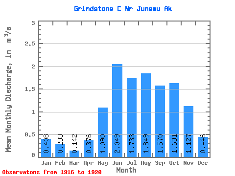
| Statistic | Jan | Feb | Mar | Apr | May | Jun | Jul | Aug | Sep | Oct | Nov | Dec | Annual |
|---|---|---|---|---|---|---|---|---|---|---|---|---|---|
| Mean | 0.41 | 0.28 | 0.14 | 0.38 | 1.09 | 2.05 | 1.73 | 1.85 | 1.57 | 1.63 | 1.13 | 0.45 | 1.04 |
| Standard Deviation | 0.12 | 0.12 | 0.05 | 0.15 | 0.18 | 0.34 | 0.62 | 0.54 | 0.48 | 0.55 | 0.69 | 0.17 | 0.20 |
| Min | 0.27 | 0.18 | 0.09 | 0.20 | 0.90 | 1.54 | 1.04 | 1.38 | 0.89 | 0.76 | 0.63 | 0.22 | 0.85 |
| Max | 0.55 | 0.42 | 0.20 | 0.55 | 1.39 | 2.32 | 2.46 | 2.57 | 1.93 | 2.25 | 2.33 | 0.70 | 1.32 |
| Coefficient of Variation | 0.30 | 0.41 | 0.37 | 0.39 | 0.17 | 0.17 | 0.36 | 0.29 | 0.31 | 0.34 | 0.62 | 0.39 | 0.19 |
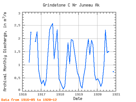
| Year | Jan | Feb | Mar | Apr | May | Jun | Jul | Aug | Sep | Oct | Nov | Dec | Annual | 1916 | 1.09 | 2.23 | 1.89 | 2.25 | 0.83 | 0.44 | 1917 | 0.27 | 0.42 | 0.20 | 0.43 | 1.39 | 2.32 | 2.46 | 2.57 | 1.22 | 1.83 | 2.33 | 0.45 | 1.32 | 1918 | 0.35 | 0.18 | 0.09 | 0.20 | 1.09 | 1.84 | 1.04 | 1.95 | 1.93 | 1.56 | 1.10 | 0.70 | 1.00 | 1919 | 0.55 | 0.20 | 0.11 | 0.55 | 0.90 | 1.54 | 1.98 | 1.38 | 1.93 | 1.75 | 0.63 | 0.41 | 0.99 | 1920 | 0.47 | 0.34 | 0.17 | 0.33 | 0.98 | 2.31 | 1.46 | 1.50 | 0.89 | 0.76 | 0.74 | 0.22 | 0.85 |
|---|
 Return to R-Arctic Net Home Page