|
|
|||||||||||||||||
| Point ID: 9231 | Downloads | Plots | Site Data | Code: 15216100 |
|
|
|||||||||||||||||
| Download | |
|---|---|
| Site Descriptor Information | Site Time Series Data |
| Link to all available data | |
|
|
| View: | Statistics | Time Series |
| Units: | mm |
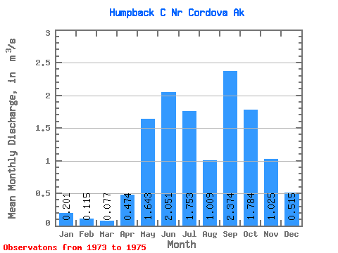
| Statistic | Jan | Feb | Mar | Apr | May | Jun | Jul | Aug | Sep | Oct | Nov | Dec | Annual |
|---|---|---|---|---|---|---|---|---|---|---|---|---|---|
| Mean | 0.20 | 0.12 | 0.08 | 0.47 | 1.64 | 2.05 | 1.75 | 1.01 | 2.37 | 1.78 | 1.02 | 0.52 | 1.09 |
| Standard Deviation | 0.07 | 0.02 | 0.02 | 0.05 | 0.28 | 0.45 | 1.01 | 0.43 | 0.13 | 1.01 | 1.12 | 0.38 | |
| Min | 0.15 | 0.10 | 0.07 | 0.44 | 1.44 | 1.73 | 1.04 | 0.70 | 2.29 | 1.07 | 0.24 | 0.24 | 1.09 |
| Max | 0.25 | 0.13 | 0.09 | 0.51 | 1.84 | 2.37 | 2.47 | 1.32 | 2.46 | 2.50 | 1.81 | 0.79 | 1.09 |
| Coefficient of Variation | 0.37 | 0.17 | 0.20 | 0.10 | 0.17 | 0.22 | 0.58 | 0.43 | 0.05 | 0.56 | 1.09 | 0.74 |
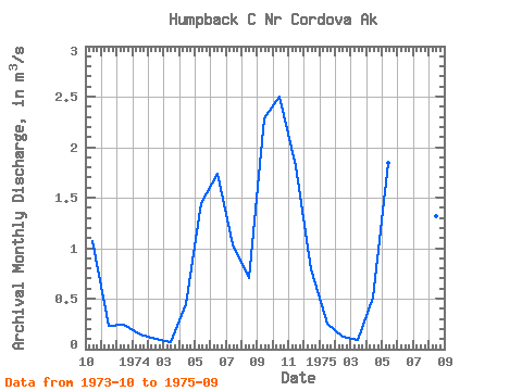
| Year | Jan | Feb | Mar | Apr | May | Jun | Jul | Aug | Sep | Oct | Nov | Dec | Annual | 1973 | 1.07 | 0.24 | 0.24 | 1974 | 0.15 | 0.10 | 0.07 | 0.44 | 1.44 | 1.73 | 1.04 | 0.70 | 2.29 | 2.50 | 1.81 | 0.79 | 1.09 | 1975 | 0.25 | 0.13 | 0.09 | 0.51 | 1.84 | 2.37 | 2.47 | 1.32 | 2.46 |
|---|
 Return to R-Arctic Net Home Page