|
|
|||||||||||||||||
| Point ID: 9229 | Downloads | Plots | Site Data | Code: 15216003 |
|
|
|||||||||||||||||
| Download | |
|---|---|
| Site Descriptor Information | Site Time Series Data |
| Link to all available data | |
|
|
| View: | Statistics | Time Series |
| Units: | mm |
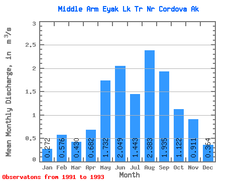
| Statistic | Jan | Feb | Mar | Apr | May | Jun | Jul | Aug | Sep | Oct | Nov | Dec | Annual |
|---|---|---|---|---|---|---|---|---|---|---|---|---|---|
| Mean | 0.27 | 0.58 | 0.43 | 0.68 | 1.73 | 2.05 | 1.44 | 2.38 | 1.94 | 1.12 | 0.91 | 0.36 | 1.14 |
| Standard Deviation | 0.10 | 0.10 | 0.27 | 0.25 | 0.47 | 0.66 | 0.65 | 0.38 | 1.55 | 0.11 | 0.54 | 0.05 | |
| Min | 0.20 | 0.51 | 0.24 | 0.51 | 1.40 | 1.58 | 0.98 | 2.12 | 0.84 | 1.04 | 0.53 | 0.33 | 1.14 |
| Max | 0.34 | 0.65 | 0.62 | 0.86 | 2.06 | 2.51 | 1.90 | 2.65 | 3.03 | 1.20 | 1.29 | 0.40 | 1.14 |
| Coefficient of Variation | 0.37 | 0.17 | 0.62 | 0.36 | 0.27 | 0.32 | 0.45 | 0.16 | 0.80 | 0.10 | 0.59 | 0.14 |
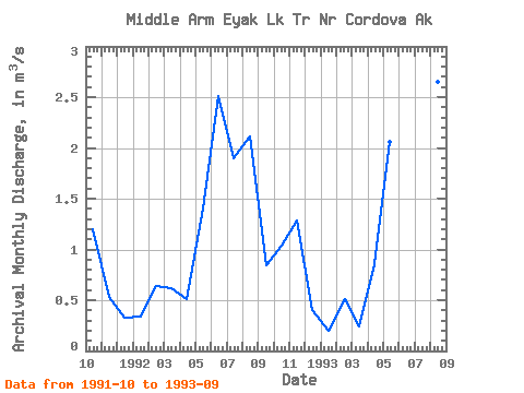
| Year | Jan | Feb | Mar | Apr | May | Jun | Jul | Aug | Sep | Oct | Nov | Dec | Annual | 1991 | 1.20 | 0.53 | 0.33 | 1992 | 0.34 | 0.65 | 0.62 | 0.51 | 1.40 | 2.51 | 1.90 | 2.12 | 0.84 | 1.04 | 1.29 | 0.40 | 1.14 | 1993 | 0.20 | 0.51 | 0.24 | 0.86 | 2.06 | 1.58 | 0.98 | 2.65 | 3.03 |
|---|
 Return to R-Arctic Net Home Page