|
|
|||||||||||||||||
| Point ID: 9227 | Downloads | Plots | Site Data | Code: 15215992 |
|
|
|||||||||||||||||
| Download | |
|---|---|
| Site Descriptor Information | Site Time Series Data |
| Link to all available data | |
|
|
| View: | Statistics | Time Series |
| Units: | mm |
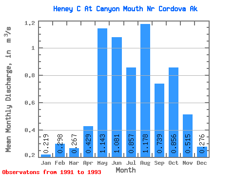
| Statistic | Jan | Feb | Mar | Apr | May | Jun | Jul | Aug | Sep | Oct | Nov | Dec | Annual |
|---|---|---|---|---|---|---|---|---|---|---|---|---|---|
| Mean | 0.22 | 0.30 | 0.27 | 0.43 | 1.14 | 1.08 | 0.86 | 1.18 | 0.74 | 0.86 | 0.52 | 0.28 | 0.69 |
| Standard Deviation | 0.19 | 0.02 | 0.28 | 0.12 | 0.40 | 0.44 | 0.51 | 0.18 | 0.60 | 0.13 | 0.33 | 0.13 | |
| Min | 0.08 | 0.28 | 0.07 | 0.34 | 0.86 | 0.77 | 0.50 | 1.05 | 0.31 | 0.76 | 0.28 | 0.18 | 0.69 |
| Max | 0.35 | 0.31 | 0.46 | 0.52 | 1.43 | 1.39 | 1.22 | 1.31 | 1.17 | 0.95 | 0.75 | 0.37 | 0.69 |
| Coefficient of Variation | 0.87 | 0.07 | 1.04 | 0.29 | 0.35 | 0.41 | 0.59 | 0.16 | 0.82 | 0.15 | 0.64 | 0.47 |
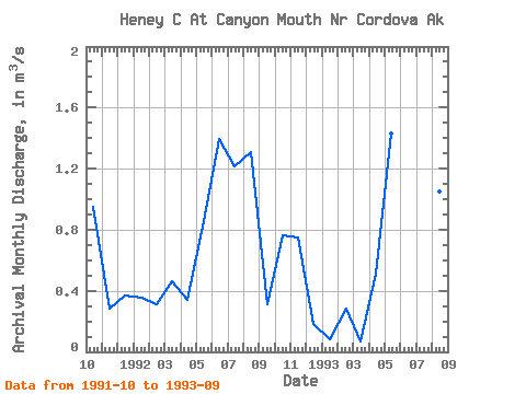
| Year | Jan | Feb | Mar | Apr | May | Jun | Jul | Aug | Sep | Oct | Nov | Dec | Annual | 1991 | 0.95 | 0.28 | 0.37 | 1992 | 0.35 | 0.31 | 0.46 | 0.34 | 0.86 | 1.39 | 1.22 | 1.31 | 0.31 | 0.76 | 0.75 | 0.18 | 0.69 | 1993 | 0.08 | 0.28 | 0.07 | 0.52 | 1.43 | 0.77 | 0.50 | 1.05 | 1.17 |
|---|
 Return to R-Arctic Net Home Page