|
|
|||||||||||||||||
| Point ID: 9211 | Downloads | Plots | Site Data | Code: 15238982 |
|
|
|||||||||||||||||
| Download | |
|---|---|
| Site Descriptor Information | Site Time Series Data |
| Link to all available data | |
|
|
| View: | Statistics | Time Series |
| Units: | mm |
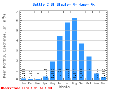
| Statistic | Jan | Feb | Mar | Apr | May | Jun | Jul | Aug | Sep | Oct | Nov | Dec | Annual |
|---|---|---|---|---|---|---|---|---|---|---|---|---|---|
| Mean | 0.20 | 0.17 | 0.15 | 0.38 | 1.90 | 4.47 | 5.80 | 6.24 | 3.70 | 2.39 | 0.70 | 0.35 | 1.53 |
| Standard Deviation | 0.02 | 0.07 | 0.06 | 0.28 | 0.89 | 0.28 | 1.13 | 1.91 | 2.50 | 2.57 | 0.46 | 0.28 | |
| Min | 0.18 | 0.13 | 0.11 | 0.18 | 1.27 | 4.28 | 4.51 | 4.20 | 1.02 | 0.83 | 0.38 | 0.15 | 1.53 |
| Max | 0.21 | 0.22 | 0.20 | 0.58 | 2.53 | 4.67 | 6.61 | 7.97 | 5.96 | 5.36 | 1.02 | 0.55 | 1.53 |
| Coefficient of Variation | 0.10 | 0.39 | 0.41 | 0.73 | 0.47 | 0.06 | 0.19 | 0.30 | 0.68 | 1.08 | 0.65 | 0.80 |
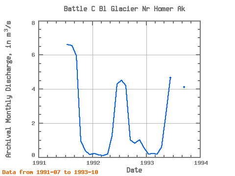
| Year | Jan | Feb | Mar | Apr | May | Jun | Jul | Aug | Sep | Oct | Nov | Dec | Annual | 1991 | 6.61 | 6.56 | 5.96 | 0.97 | 0.38 | 0.15 | 1992 | 0.21 | 0.13 | 0.11 | 0.18 | 1.27 | 4.28 | 4.51 | 4.20 | 1.02 | 0.83 | 1.02 | 0.55 | 1.53 | 1993 | 0.18 | 0.22 | 0.20 | 0.58 | 2.53 | 4.67 | 6.28 | 7.97 | 4.11 | 5.36 |
|---|
 Return to R-Arctic Net Home Page