|
|
|||||||||||||||||
| Point ID: 9171 | Downloads | Plots | Site Data | Code: 15087560 |
|
|
|||||||||||||||||
| Download | |
|---|---|
| Site Descriptor Information | Site Time Series Data |
| Link to all available data | |
|
|
| View: | Statistics | Time Series |
| Units: | mm |
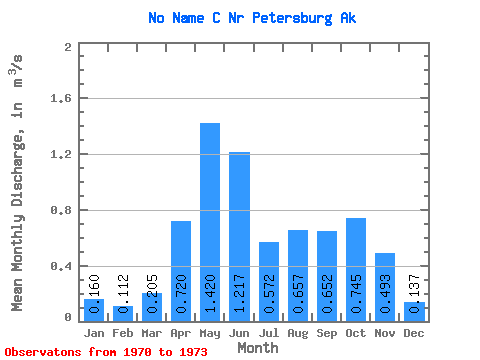
| Statistic | Jan | Feb | Mar | Apr | May | Jun | Jul | Aug | Sep | Oct | Nov | Dec | Annual |
|---|---|---|---|---|---|---|---|---|---|---|---|---|---|
| Mean | 0.16 | 0.11 | 0.20 | 0.72 | 1.42 | 1.22 | 0.57 | 0.66 | 0.65 | 0.74 | 0.49 | 0.14 | 0.62 |
| Standard Deviation | 0.04 | 0.08 | 0.14 | 0.54 | 0.10 | 0.38 | 0.25 | 0.24 | 0.14 | 0.43 | 0.35 | 0.05 | 0.01 |
| Min | 0.12 | 0.05 | 0.05 | 0.17 | 1.30 | 0.79 | 0.40 | 0.48 | 0.51 | 0.28 | 0.10 | 0.08 | 0.62 |
| Max | 0.19 | 0.20 | 0.33 | 1.25 | 1.49 | 1.49 | 0.85 | 0.93 | 0.80 | 1.13 | 0.79 | 0.18 | 0.63 |
| Coefficient of Variation | 0.25 | 0.69 | 0.69 | 0.75 | 0.07 | 0.31 | 0.43 | 0.36 | 0.22 | 0.57 | 0.72 | 0.37 | 0.02 |
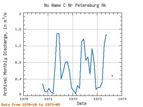
| Year | Jan | Feb | Mar | Apr | May | Jun | Jul | Aug | Sep | Oct | Nov | Dec | Annual | 1970 | 0.28 | 0.10 | 0.08 | 1971 | 0.17 | 0.09 | 0.05 | 0.74 | 1.49 | 1.49 | 0.40 | 0.57 | 0.80 | 0.82 | 0.59 | 0.18 | 0.62 | 1972 | 0.12 | 0.05 | 0.24 | 0.17 | 1.30 | 1.37 | 0.85 | 0.93 | 0.51 | 1.13 | 0.79 | 0.14 | 0.63 | 1973 | 0.19 | 0.20 | 0.33 | 1.25 | 1.46 | 0.79 | 0.47 | 0.48 | 0.65 |
|---|
 Return to R-Arctic Net Home Page