|
|
|||||||||||||||||
| Point ID: 9158 | Downloads | Plots | Site Data | Code: 15108800 |
|
|
|||||||||||||||||
| Download | |
|---|---|
| Site Descriptor Information | Site Time Series Data |
| Link to all available data | |
|
|
| View: | Statistics | Time Series |
| Units: | mm |
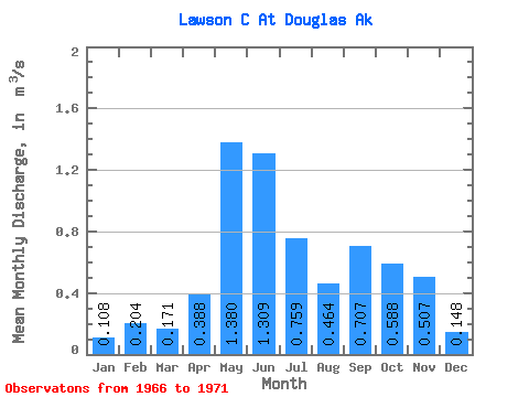
| Statistic | Jan | Feb | Mar | Apr | May | Jun | Jul | Aug | Sep | Oct | Nov | Dec | Annual |
|---|---|---|---|---|---|---|---|---|---|---|---|---|---|
| Mean | 0.11 | 0.20 | 0.17 | 0.39 | 1.38 | 1.31 | 0.76 | 0.46 | 0.71 | 0.59 | 0.51 | 0.15 | 0.47 |
| Standard Deviation | 0.07 | 0.16 | 0.15 | 0.13 | 0.62 | 1.37 | 0.57 | 0.28 | 0.30 | 0.29 | 0.29 | 0.11 | 0.09 |
| Min | 0.03 | 0.02 | 0.03 | 0.21 | 0.81 | 0.29 | 0.14 | 0.13 | 0.46 | 0.20 | 0.27 | 0.01 | 0.39 |
| Max | 0.16 | 0.40 | 0.35 | 0.56 | 2.26 | 3.71 | 1.68 | 0.85 | 1.09 | 1.00 | 1.02 | 0.28 | 0.60 |
| Coefficient of Variation | 0.60 | 0.80 | 0.88 | 0.35 | 0.45 | 1.05 | 0.75 | 0.60 | 0.43 | 0.49 | 0.58 | 0.73 | 0.20 |
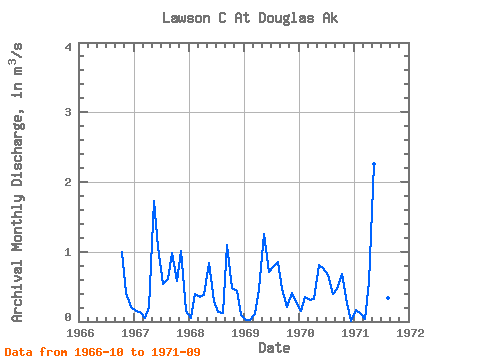
| Year | Jan | Feb | Mar | Apr | May | Jun | Jul | Aug | Sep | Oct | Nov | Dec | Annual | 1966 | 1.00 | 0.41 | 0.21 | 1967 | 0.15 | 0.13 | 0.06 | 0.21 | 1.73 | 1.06 | 0.53 | 0.61 | 0.98 | 0.59 | 1.02 | 0.16 | 0.60 | 1968 | 0.05 | 0.40 | 0.35 | 0.39 | 0.84 | 0.29 | 0.14 | 0.13 | 1.09 | 0.47 | 0.43 | 0.09 | 0.39 | 1969 | 0.03 | 0.02 | 0.10 | 0.46 | 1.25 | 0.71 | 0.78 | 0.85 | 0.47 | 0.20 | 0.41 | 0.28 | 0.46 | 1970 | 0.15 | 0.35 | 0.31 | 0.32 | 0.81 | 0.77 | 0.67 | 0.39 | 0.46 | 0.68 | 0.27 | 0.01 | 0.43 | 1971 | 0.16 | 0.12 | 0.03 | 0.56 | 2.26 | 3.71 | 1.68 | 0.34 | 0.54 |
|---|
 Return to R-Arctic Net Home Page