|
|
|||||||||||||||||
| Point ID: 9152 | Downloads | Plots | Site Data | Code: 15087000 |
|
|
|||||||||||||||||
| Download | |
|---|---|
| Site Descriptor Information | Site Time Series Data |
| Link to all available data | |
|
|
| View: | Statistics | Time Series |
| Units: | mm |
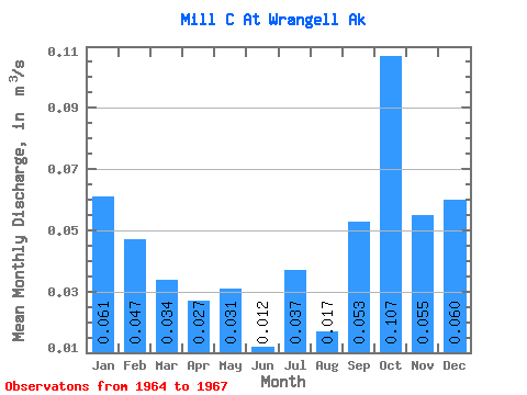
| Statistic | Jan | Feb | Mar | Apr | May | Jun | Jul | Aug | Sep | Oct | Nov | Dec | Annual |
|---|---|---|---|---|---|---|---|---|---|---|---|---|---|
| Mean | 0.06 | 0.05 | 0.03 | 0.03 | 0.03 | 0.01 | 0.04 | 0.02 | 0.05 | 0.11 | 0.06 | 0.06 | 0.04 |
| Standard Deviation | 0.04 | 0.04 | 0.02 | 0.01 | 0.01 | 0.01 | 0.06 | 0.01 | 0.04 | 0.04 | 0.03 | 0.03 | 0.01 |
| Min | 0.01 | 0.01 | 0.02 | 0.02 | 0.03 | 0.01 | 0.00 | 0.01 | 0.01 | 0.07 | 0.04 | 0.04 | 0.03 |
| Max | 0.10 | 0.09 | 0.05 | 0.03 | 0.04 | 0.02 | 0.10 | 0.03 | 0.08 | 0.15 | 0.08 | 0.09 | 0.05 |
| Coefficient of Variation | 0.74 | 0.81 | 0.47 | 0.35 | 0.26 | 0.55 | 1.59 | 0.56 | 0.74 | 0.35 | 0.45 | 0.41 | 0.22 |
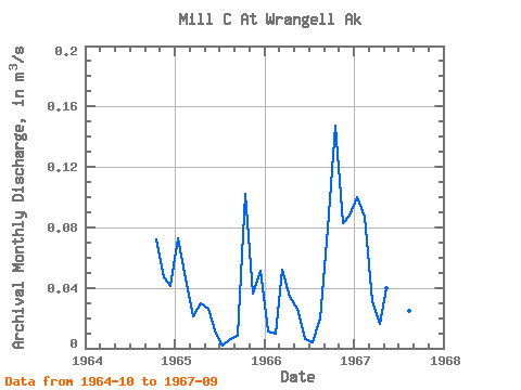
| Year | Jan | Feb | Mar | Apr | May | Jun | Jul | Aug | Sep | Oct | Nov | Dec | Annual | 1964 | 0.07 | 0.05 | 0.04 | 1965 | 0.07 | 0.05 | 0.02 | 0.03 | 0.03 | 0.01 | 0.00 | 0.01 | 0.01 | 0.10 | 0.04 | 0.05 | 0.03 | 1966 | 0.01 | 0.01 | 0.05 | 0.03 | 0.03 | 0.01 | 0.00 | 0.02 | 0.08 | 0.15 | 0.08 | 0.09 | 0.05 | 1967 | 0.10 | 0.09 | 0.03 | 0.02 | 0.04 | 0.02 | 0.10 | 0.03 | 0.07 |
|---|
 Return to R-Arctic Net Home Page