|
|
|||||||||||||||||
| Point ID: 9141 | Downloads | Plots | Site Data | Code: 15101200 |
|
|
|||||||||||||||||
| Download | |
|---|---|
| Site Descriptor Information | Site Time Series Data |
| Link to all available data | |
|
|
| View: | Statistics | Time Series |
| Units: | mm |
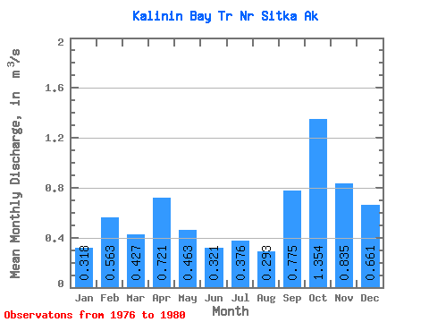
| Statistic | Jan | Feb | Mar | Apr | May | Jun | Jul | Aug | Sep | Oct | Nov | Dec | Annual |
|---|---|---|---|---|---|---|---|---|---|---|---|---|---|
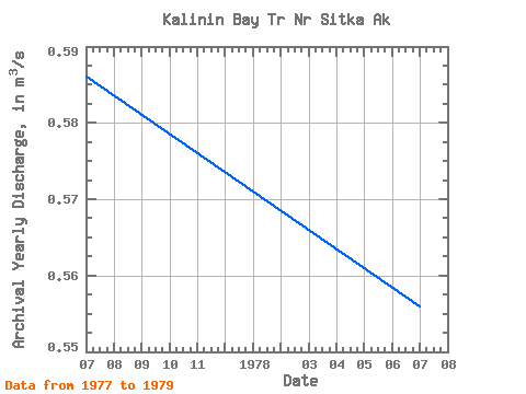
| Mean | 0.32 | 0.56 | 0.43 | 0.72 | 0.46 | 0.32 | 0.38 | 0.29 | 0.78 | 1.35 | 0.83 | 0.66 | 0.56 |
| Standard Deviation | 0.27 | 0.64 | 0.04 | 0.33 | 0.15 | 0.08 | 0.19 | 0.19 | 0.38 | 0.38 | 0.30 | 0.39 | 0.02 |
| Min | 0.13 | 0.12 | 0.36 | 0.32 | 0.34 | 0.23 | 0.17 | 0.10 | 0.43 | 0.96 | 0.46 | 0.09 | 0.55 |
| Max | 0.70 | 1.49 | 0.47 | 1.00 | 0.65 | 0.40 | 0.63 | 0.53 | 1.40 | 1.87 | 1.12 | 0.92 | 0.59 |
| Coefficient of Variation | 0.84 | 1.13 | 0.10 | 0.46 | 0.33 | 0.26 | 0.51 | 0.63 | 0.49 | 0.28 | 0.36 | 0.59 | 0.03 |
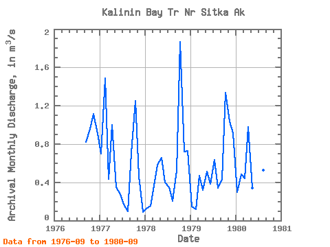
| Year | Jan | Feb | Mar | Apr | May | Jun | Jul | Aug | Sep | Oct | Nov | Dec | Annual | 1976 | 0.82 | 0.96 | 1.12 | 0.91 | 1977 | 0.70 | 1.49 | 0.43 | 1.00 | 0.35 | 0.28 | 0.17 | 0.10 | 0.70 | 1.25 | 0.46 | 0.09 | 0.59 | 1978 | 0.13 | 0.16 | 0.36 | 0.58 | 0.65 | 0.40 | 0.34 | 0.21 | 0.52 | 1.87 | 0.72 | 0.73 | 0.56 | 1979 | 0.14 | 0.12 | 0.47 | 0.32 | 0.51 | 0.38 | 0.63 | 0.34 | 0.43 | 1.34 | 1.04 | 0.92 | 0.55 | 1980 | 0.30 | 0.49 | 0.44 | 0.98 | 0.34 | 0.23 | 0.36 | 0.53 | 1.40 |
|---|
 Return to R-Arctic Net Home Page