|
|
|||||||||||||||||
| Point ID: 9139 | Downloads | Plots | Site Data | Code: 15266300 |
|
|
|||||||||||||||||
| Download | |
|---|---|
| Site Descriptor Information | Site Time Series Data |
| Link to all available data | |
|
|
| View: | Statistics | Time Series |
| Units: | mm |
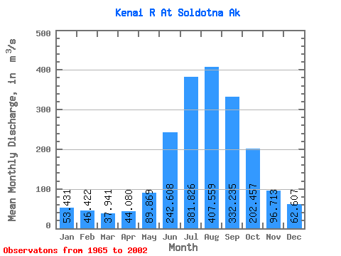
| Statistic | Jan | Feb | Mar | Apr | May | Jun | Jul | Aug | Sep | Oct | Nov | Dec | Annual |
|---|---|---|---|---|---|---|---|---|---|---|---|---|---|
| Mean | 53.43 | 46.42 | 37.94 | 44.08 | 89.87 | 242.61 | 381.83 | 407.56 | 332.24 | 202.46 | 96.71 | 62.61 | 167.10 |
| Standard Deviation | 23.11 | 23.51 | 12.69 | 12.85 | 28.31 | 59.48 | 56.69 | 87.86 | 116.13 | 84.41 | 36.96 | 26.87 | 29.24 |
| Min | 23.29 | 23.29 | 22.65 | 22.98 | 55.22 | 139.88 | 274.56 | 246.54 | 166.29 | 80.76 | 46.17 | 32.06 | 107.36 |
| Max | 121.47 | 129.55 | 76.34 | 80.31 | 159.85 | 355.94 | 530.53 | 704.82 | 602.68 | 407.04 | 207.69 | 154.87 | 232.99 |
| Coefficient of Variation | 0.43 | 0.51 | 0.34 | 0.29 | 0.32 | 0.24 | 0.15 | 0.22 | 0.35 | 0.42 | 0.38 | 0.43 | 0.17 |
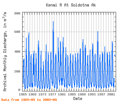
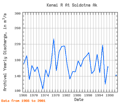
| Year | Jan | Feb | Mar | Apr | May | Jun | Jul | Aug | Sep | Oct | Nov | Dec | Annual | 1965 | 74.47 | 185.05 | 305.33 | 323.93 | 326.74 | 178.53 | 60.41 | 42.48 | 1966 | 33.98 | 28.32 | 24.07 | 24.32 | 56.51 | 191.91 | 309.21 | 537.11 | 485.44 | 241.77 | 78.66 | 43.85 | 171.26 | 1967 | 34.98 | 31.15 | 31.15 | 31.15 | 60.41 | 241.37 | 382.73 | 537.11 | 590.22 | 207.34 | 82.73 | 61.20 | 190.96 | 1968 | 47.41 | 45.75 | 50.42 | 42.81 | 95.18 | 239.47 | 337.13 | 371.15 | 177.62 | 81.00 | 46.47 | 40.01 | 131.20 | 1969 | 80.47 | 68.45 | 45.22 | 42.08 | 62.94 | 289.36 | 376.34 | 246.54 | 166.29 | 407.04 | 127.62 | 80.09 | 166.04 | 1970 | 66.01 | 49.62 | 49.93 | 48.37 | 77.98 | 226.04 | 329.17 | 384.10 | 275.79 | 116.37 | 125.51 | 63.27 | 151.01 | 1971 | 49.69 | 35.40 | 32.52 | 32.56 | 55.56 | 191.42 | 431.51 | 508.42 | 371.04 | 136.13 | 65.74 | 46.13 | 163.01 | 1972 | 35.26 | 27.44 | 24.02 | 22.98 | 67.26 | 139.88 | 323.86 | 405.30 | 324.84 | 128.45 | 69.61 | 44.58 | 134.46 | 1973 | 33.89 | 27.00 | 23.84 | 28.25 | 55.22 | 154.55 | 274.56 | 298.30 | 213.68 | 99.21 | 46.17 | 33.71 | 107.36 | 1974 | 30.23 | 25.84 | 24.62 | 37.80 | 63.38 | 192.67 | 315.36 | 322.63 | 469.30 | 243.24 | 95.57 | 46.44 | 155.59 | 1975 | 37.36 | 32.46 | 29.60 | 30.79 | 106.21 | 208.17 | 391.60 | 343.91 | 228.65 | 157.97 | 51.33 | 32.06 | 137.51 | 1976 | 23.29 | 23.29 | 22.65 | 28.36 | 59.37 | 193.98 | 355.79 | 386.48 | 391.36 | 233.42 | 131.46 | 154.87 | 167.03 | 1977 | 84.63 | 93.42 | 70.10 | 51.84 | 99.02 | 332.81 | 530.53 | 704.82 | 492.03 | 194.62 | 93.05 | 48.98 | 232.99 | 1978 | 37.50 | 34.38 | 32.69 | 39.28 | 84.04 | 213.86 | 347.38 | 381.18 | 342.63 | 182.66 | 91.96 | 54.26 | 153.49 | 1979 | 34.25 | 24.11 | 24.32 | 43.75 | 90.09 | 207.80 | 383.70 | 541.58 | 337.87 | 396.07 | 207.69 | 137.06 | 202.36 | 1980 | 92.03 | 107.25 | 60.68 | 80.31 | 132.54 | 355.94 | 503.49 | 476.18 | 261.04 | 291.89 | 154.16 | 59.47 | 214.58 | 1981 | 121.47 | 129.55 | 76.34 | 61.33 | 144.21 | 321.72 | 450.88 | 544.78 | 344.62 | 160.93 | 137.48 | 83.16 | 214.71 | 1982 | 68.33 | 55.42 | 41.84 | 40.68 | 59.26 | 186.34 | 333.59 | 330.94 | 438.91 | 309.69 | 74.63 | 52.16 | 165.98 | 1983 | 47.35 | 39.29 | 29.87 | 41.75 | 88.57 | 253.37 | 361.45 | 328.09 | 170.98 | 102.14 | 68.84 | 60.63 | 132.69 | 1984 | 54.99 | 52.63 | 50.81 | 53.30 | 84.45 | 209.47 | 354.69 | 380.73 | 234.17 | 221.98 | 72.30 | 45.98 | 151.29 | 1985 | 44.33 | 44.39 | 32.11 | 33.60 | 62.90 | 193.74 | 368.53 | 348.02 | 249.86 | 171.44 | 136.35 | 117.83 | 150.26 | 1986 | 96.66 | 64.52 | 51.75 | 41.65 | 82.18 | 231.44 | 379.08 | 379.17 | 302.04 | 280.94 | 125.03 | 100.00 | 177.87 | 1987 | 81.51 | 61.35 | 37.67 | 47.58 | 89.00 | 233.21 | 372.60 | 386.84 | 252.12 | 225.17 | 112.52 | 58.80 | 163.20 | 1988 | 43.75 | 36.42 | 36.87 | 56.46 | 121.12 | 321.92 | 422.83 | 429.05 | 333.38 | 214.04 | 125.93 | 60.84 | 183.55 | 1989 | 52.98 | 43.99 | 39.83 | 45.12 | 97.58 | 185.40 | 379.04 | 462.57 | 522.45 | 287.46 | 101.39 | 62.79 | 190.05 | 1990 | 52.71 | 45.41 | 41.65 | 62.55 | 159.85 | 349.10 | 418.63 | 466.95 | 397.29 | 162.78 | 168.56 | 57.72 | 198.60 | 1991 | 33.98 | 29.73 | 27.22 | 33.18 | 67.47 | 200.82 | 354.51 | 363.19 | 348.94 | 178.86 | 67.81 | 51.79 | 146.46 | 1992 | 42.75 | 36.23 | 33.98 | 48.53 | 108.20 | 315.01 | 416.35 | 412.06 | 194.87 | 80.76 | 70.26 | 82.65 | 153.47 | 1993 | 43.39 | 38.13 | 38.49 | 51.75 | 129.77 | 290.76 | 373.60 | 480.47 | 454.01 | 257.97 | 102.12 | 69.44 | 194.16 | 1994 | 66.63 | 60.35 | 45.12 | 48.20 | 90.17 | 249.93 | 358.25 | 378.35 | 241.96 | 130.54 | 64.48 | 47.04 | 148.42 | 1995 | 33.01 | 26.80 | 32.24 | 72.16 | 159.00 | 291.78 | 443.02 | 405.57 | 602.68 | 394.95 | 92.83 | 50.88 | 217.08 | 1996 | 43.39 | 32.52 | 28.83 | 37.76 | 66.33 | 159.27 | 312.39 | 369.45 | 208.97 | 93.66 | 49.39 | 35.62 | 119.80 | 1997 | 30.88 | 31.15 | 27.50 | 32.52 | 80.66 | 210.65 | 394.88 | 375.33 | 363.13 | 226.20 | 109.35 | 68.75 | 162.58 | 1998 | 42.29 | 32.87 | 36.35 | 56.11 | 96.55 | 327.76 | 447.86 | 323.46 | 256.77 | 183.58 | 89.99 | 49.78 | 161.95 | 1999 | 34.71 | 33.68 | 28.68 | 36.66 | 80.20 | 252.94 | 384.74 | 389.95 | 343.25 | 186.68 | 133.92 | 52.93 | 163.20 | 2000 | 51.70 | 44.43 | 36.99 | 49.87 | 90.67 | 234.84 | 395.43 | 337.13 | 179.23 | 129.57 | 82.12 | 68.93 | 141.74 | 2001 | 92.78 | 72.93 | 46.98 | 58.11 | 92.51 | 317.69 | 504.04 | 463.67 | 437.50 | 195.83 | 64.93 | 50.28 | 199.77 | 2002 | 76.36 | 51.98 | 36.86 | 37.44 | 124.21 | 317.68 | 385.29 | 362.73 | 293.28 |
|---|
 Return to R-Arctic Net Home Page