|
|
|||||||||||||||||
| Point ID: 9133 | Downloads | Plots | Site Data | Code: 07FA007 |
|
|
|||||||||||||||||
| Download | |
|---|---|
| Site Descriptor Information | Site Time Series Data |
| Link to all available data | |
|
|
| View: | Statistics | Time Series |
| Units: | mm |
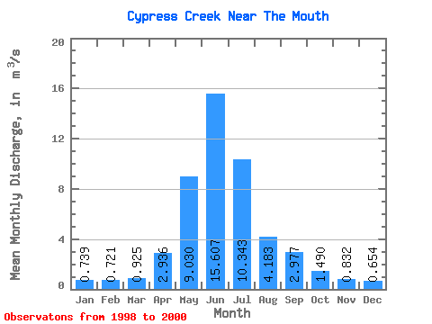
| Statistic | Jan | Feb | Mar | Apr | May | Jun | Jul | Aug | Sep | Oct | Nov | Dec | Annual |
|---|---|---|---|---|---|---|---|---|---|---|---|---|---|
| Mean | 0.74 | 0.72 | 0.93 | 2.94 | 9.03 | 15.61 | 10.34 | 4.18 | 2.98 | 1.49 | 0.83 | 0.65 | 4.20 |
| Standard Deviation | 0.34 | 0.39 | 0.66 | 2.50 | 8.71 | 4.97 | 7.60 | 2.61 | 2.44 | 0.26 | 0.33 | 0.30 | 0.74 |
| Min | 0.35 | 0.32 | 0.41 | 0.92 | 2.41 | 9.92 | 5.52 | 2.61 | 1.43 | 1.27 | 0.52 | 0.46 | 3.42 |
| Max | 0.99 | 1.10 | 1.67 | 5.73 | 18.90 | 19.10 | 19.10 | 7.20 | 5.79 | 1.78 | 1.17 | 1.00 | 4.89 |
| Coefficient of Variation | 0.46 | 0.55 | 0.71 | 0.85 | 0.96 | 0.32 | 0.73 | 0.62 | 0.82 | 0.18 | 0.39 | 0.46 | 0.17 |
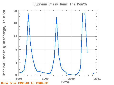
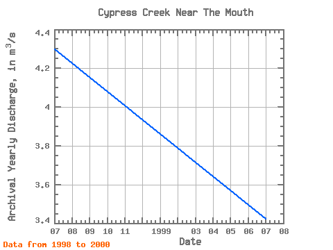
| Year | Jan | Feb | Mar | Apr | May | Jun | Jul | Aug | Sep | Oct | Nov | Dec | Annual | 1998 | 0.99 | 1.10 | 1.67 | 5.73 | 18.90 | 9.92 | 5.52 | 2.74 | 1.43 | 1.42 | 1.17 | 1.00 | 4.30 | 1999 | 0.88 | 0.75 | 0.70 | 2.16 | 5.78 | 17.80 | 6.41 | 2.61 | 1.71 | 1.27 | 0.52 | 0.50 | 3.42 | 2000 | 0.35 | 0.32 | 0.41 | 0.92 | 2.41 | 19.10 | 19.10 | 7.20 | 5.79 | 1.78 | 0.81 | 0.46 | 4.89 |
|---|
 Return to R-Arctic Net Home Page