|
|
|||||||||||||||||
| Point ID: 9079 | Downloads | Plots | Site Data | Code: 49148 |
|
|
|||||||||||||||||
| Download | |
|---|---|
| Site Descriptor Information | Site Time Series Data |
| Link to all available data | |
|
|
| View: | Statistics | Time Series |
| Units: | mm |
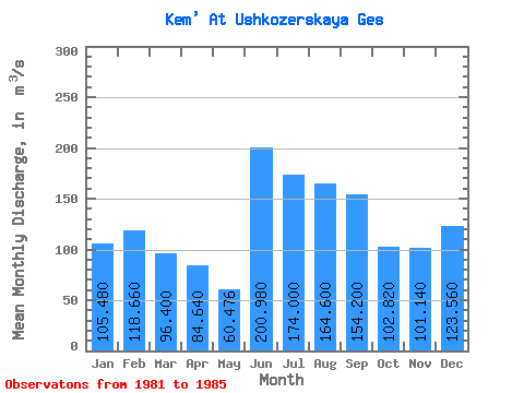
| Statistic | Jan | Feb | Mar | Apr | May | Jun | Jul | Aug | Sep | Oct | Nov | Dec | Annual |
|---|---|---|---|---|---|---|---|---|---|---|---|---|---|
| Mean | 105.48 | 118.66 | 96.40 | 84.64 | 60.48 | 200.98 | 174.00 | 164.60 | 154.20 | 102.82 | 101.14 | 123.56 | 123.91 |
| Standard Deviation | 46.08 | 43.24 | 39.42 | 28.37 | 59.45 | 111.10 | 52.47 | 18.82 | 22.99 | 67.41 | 30.74 | 41.00 | 12.51 |
| Min | 40.60 | 49.30 | 39.00 | 43.40 | 0.68 | 61.90 | 118.00 | 138.00 | 135.00 | 35.10 | 61.00 | 92.70 | 104.04 |
| Max | 168.00 | 162.00 | 148.00 | 123.00 | 126.00 | 317.00 | 242.00 | 191.00 | 193.00 | 216.00 | 147.00 | 192.00 | 134.81 |
| Coefficient of Variation | 0.44 | 0.36 | 0.41 | 0.34 | 0.98 | 0.55 | 0.30 | 0.11 | 0.15 | 0.66 | 0.30 | 0.33 | 0.10 |
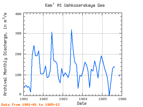
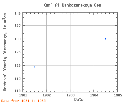
| Year | Jan | Feb | Mar | Apr | May | Jun | Jul | Aug | Sep | Oct | Nov | Dec | Annual | 1981 | 40.60 | 49.30 | 39.00 | 43.40 | 16.30 | 193.00 | 242.00 | 191.00 | 193.00 | 216.00 | 105.00 | 104.00 | 119.38 | 1982 | 108.00 | 142.00 | 86.80 | 89.50 | 122.00 | 306.00 | 168.00 | 165.00 | 155.00 | 83.40 | 61.00 | 131.00 | 134.81 | 1983 | 91.80 | 109.00 | 99.20 | 87.00 | 126.00 | 317.00 | 211.00 | 162.00 | 148.00 | 35.10 | 97.70 | 92.70 | 131.38 | 1984 | 119.00 | 162.00 | 148.00 | 123.00 | 37.40 | 127.00 | 118.00 | 167.00 | 135.00 | 84.10 | 147.00 | 192.00 | 129.96 | 1985 | 168.00 | 131.00 | 109.00 | 80.30 | 0.68 | 61.90 | 131.00 | 138.00 | 140.00 | 95.50 | 95.00 | 98.10 | 104.04 |
|---|
 Return to R-Arctic Net Home Page