|
|
|||||||||||||||||
| Point ID: 9058 | Downloads | Plots | Site Data | Code: 49057 |
|
|
|||||||||||||||||
| Download | |
|---|---|
| Site Descriptor Information | Site Time Series Data |
| Link to all available data | |
|
|
| View: | Statistics | Time Series |
| Units: | mm |
| Statistic | Jan | Feb | Mar | Apr | May | Jun | Jul | Aug | Sep | Oct | Nov | Dec | Annual |
|---|---|---|---|---|---|---|---|---|---|---|---|---|---|
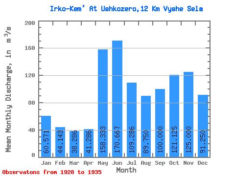
| Mean | 60.57 | 44.14 | 38.29 | 41.29 | 158.33 | 170.67 | 109.29 | 89.75 | 100.00 | 121.12 | 125.00 | 91.25 | 96.50 |
| Standard Deviation | 13.41 | 11.08 | 7.72 | 13.36 | 49.81 | 39.81 | 46.19 | 34.35 | 37.84 | 51.23 | 35.19 | 14.82 | 11.63 |
| Min | 42.00 | 29.00 | 26.00 | 24.00 | 106.00 | 111.00 | 57.00 | 56.00 | 48.00 | 74.00 | 87.00 | 70.00 | 80.58 |
| Max | 80.00 | 65.00 | 50.00 | 66.00 | 245.00 | 207.00 | 173.00 | 146.00 | 167.00 | 233.00 | 204.00 | 110.00 | 111.17 |
| Coefficient of Variation | 0.22 | 0.25 | 0.20 | 0.32 | 0.32 | 0.23 | 0.42 | 0.38 | 0.38 | 0.42 | 0.28 | 0.16 | 0.12 |
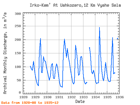
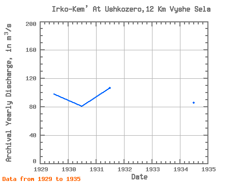
| Year | Jan | Feb | Mar | Apr | May | Jun | Jul | Aug | Sep | Oct | Nov | Dec | Annual | 1928 | 102.00 | 91.00 | 87.00 | 120.00 | 90.00 | 1929 | 67.00 | 46.00 | 35.00 | 30.00 | 156.00 | 204.00 | 79.00 | 78.00 | 137.00 | 122.00 | 120.00 | 100.00 | 97.83 | 1930 | 80.00 | 65.00 | 50.00 | 66.00 | 106.00 | 111.00 | 57.00 | 56.00 | 91.00 | 110.00 | 100.00 | 75.00 | 80.58 | 1931 | 42.00 | 29.00 | 26.00 | 24.00 | 145.00 | 202.00 | 173.00 | 134.00 | 167.00 | 132.00 | 116.00 | 85.00 | 106.25 | 1932 | 68.00 | 44.00 | 36.00 | 41.00 | 179.00 | 157.00 | 118.00 | 68.00 | 73.00 | 135.00 | 137.00 | 110.00 | 97.17 | 1933 | 64.00 | 41.00 | 36.00 | 41.00 | 169.00 | 146.00 | 80.00 | 74.00 | 87.00 | 70.00 | 1934 | 45.00 | 37.00 | 40.00 | 40.00 | 245.00 | 143.00 | 95.00 | 57.00 | 48.00 | 76.00 | 116.00 | 90.00 | 86.00 | 1935 | 58.00 | 47.00 | 45.00 | 47.00 | 119.00 | 207.00 | 74.00 | 77.00 | 113.00 | 233.00 | 204.00 | 110.00 | 111.17 |
|---|
 Return to R-Arctic Net Home Page