|
|
|||||||||||||||||
| Point ID: 9057 | Downloads | Plots | Site Data | Code: 49056 |
|
|
|||||||||||||||||
| Download | |
|---|---|
| Site Descriptor Information | Site Time Series Data |
| Link to all available data | |
|
|
| View: | Statistics | Time Series |
| Units: | mm |
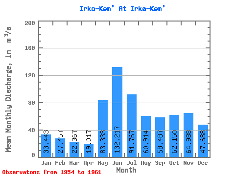
| Statistic | Jan | Feb | Mar | Apr | May | Jun | Jul | Aug | Sep | Oct | Nov | Dec | Annual |
|---|---|---|---|---|---|---|---|---|---|---|---|---|---|
| Mean | 33.44 | 27.46 | 22.37 | 19.02 | 83.33 | 132.22 | 91.77 | 60.91 | 58.49 | 62.15 | 64.99 | 47.69 | 54.67 |
| Standard Deviation | 15.47 | 12.04 | 10.17 | 6.86 | 37.72 | 80.69 | 37.13 | 25.33 | 36.51 | 34.38 | 34.78 | 24.22 | 20.56 |
| Min | 13.20 | 12.80 | 11.80 | 14.50 | 44.50 | 46.40 | 45.70 | 31.20 | 24.20 | 22.30 | 20.70 | 16.20 | 31.45 |
| Max | 52.20 | 45.40 | 37.80 | 32.80 | 135.00 | 227.00 | 136.00 | 108.00 | 130.00 | 121.00 | 119.00 | 86.80 | 78.83 |
| Coefficient of Variation | 0.46 | 0.44 | 0.46 | 0.36 | 0.45 | 0.61 | 0.41 | 0.42 | 0.62 | 0.55 | 0.54 | 0.51 | 0.38 |
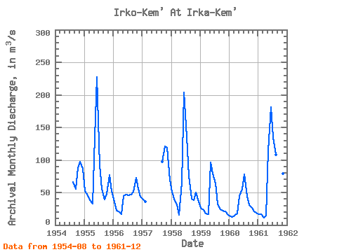
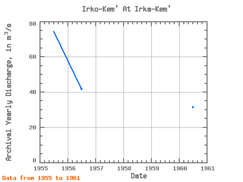
| Year | Jan | Feb | Mar | Apr | May | Jun | Jul | Aug | Sep | Oct | Nov | Dec | Annual | 1954 | 66.20 | 55.50 | 88.00 | 97.30 | 86.80 | 1955 | 52.20 | 45.40 | 37.80 | 32.80 | 135.00 | 227.00 | 91.40 | 55.80 | 39.00 | 48.00 | 77.00 | 51.90 | 74.44 | 1956 | 36.20 | 21.60 | 20.50 | 16.50 | 44.50 | 46.40 | 45.70 | 47.20 | 51.30 | 72.20 | 55.10 | 44.00 | 41.77 | 1957 | 38.80 | 36.10 | 97.10 | 121.00 | 119.00 | 69.60 | 1958 | 50.80 | 36.70 | 31.60 | 15.80 | 65.40 | 204.00 | 136.00 | 74.80 | 40.10 | 37.70 | 50.30 | 36.20 | 64.95 | 1959 | 26.40 | 23.10 | 17.60 | 16.30 | 96.50 | 79.40 | 64.10 | 31.20 | 24.20 | 22.30 | 21.50 | 16.20 | 36.57 | 1960 | 13.20 | 12.80 | 14.90 | 18.20 | 44.60 | 55.50 | 78.40 | 43.20 | 30.70 | 26.40 | 20.70 | 18.80 | 31.45 | 1961 | 16.50 | 16.50 | 11.80 | 14.50 | 114.00 | 181.00 | 135.00 | 108.00 | 130.00 | 81.60 | 79.00 | 58.00 | 78.83 |
|---|
 Return to R-Arctic Net Home Page