|
|
|||||||||||||||||
| Point ID: 9051 | Downloads | Plots | Site Data | Code: 49012 |
|
|
|||||||||||||||||
| Download | |
|---|---|
| Site Descriptor Information | Site Time Series Data |
| Link to all available data | |
|
|
| View: | Statistics | Time Series |
| Units: | mm |
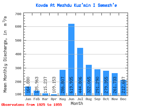
| Statistic | Jan | Feb | Mar | Apr | May | Jun | Jul | Aug | Sep | Oct | Nov | Dec | Annual |
|---|---|---|---|---|---|---|---|---|---|---|---|---|---|
| Mean | 164.88 | 135.96 | 115.24 | 109.15 | 286.81 | 619.93 | 444.81 | 322.06 | 291.29 | 279.36 | 261.73 | 212.69 | 270.85 |
| Standard Deviation | 49.15 | 34.27 | 28.04 | 22.29 | 135.86 | 159.12 | 107.64 | 87.55 | 102.28 | 126.74 | 108.65 | 74.50 | 60.77 |
| Min | 84.10 | 72.20 | 47.90 | 66.30 | 96.20 | 323.00 | 243.00 | 157.00 | 134.00 | 128.00 | 124.00 | 98.60 | 147.41 |
| Max | 263.00 | 198.00 | 164.00 | 149.00 | 558.00 | 890.00 | 683.00 | 517.00 | 490.00 | 733.00 | 591.00 | 374.00 | 418.58 |
| Coefficient of Variation | 0.30 | 0.25 | 0.24 | 0.20 | 0.47 | 0.26 | 0.24 | 0.27 | 0.35 | 0.45 | 0.41 | 0.35 | 0.22 |
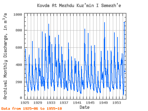
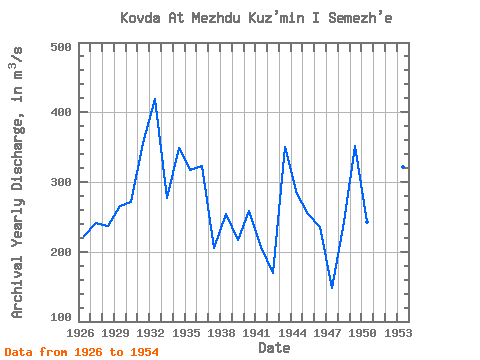
| Year | Jan | Feb | Mar | Apr | May | Jun | Jul | Aug | Sep | Oct | Nov | Dec | Annual | 1925 | 584.00 | 354.00 | 223.00 | 195.00 | 183.00 | 157.00 | 131.00 | 1926 | 111.00 | 98.00 | 92.00 | 88.00 | 148.00 | 466.00 | 514.00 | 311.00 | 227.00 | 211.00 | 204.00 | 193.00 | 221.92 | 1927 | 152.00 | 127.00 | 111.00 | 101.00 | 131.00 | 672.00 | 485.00 | 289.00 | 268.00 | 227.00 | 184.00 | 152.00 | 241.58 | 1928 | 129.00 | 116.00 | 100.00 | 94.00 | 224.00 | 467.00 | 352.00 | 337.00 | 363.00 | 261.00 | 207.00 | 195.00 | 237.08 | 1929 | 160.00 | 132.00 | 113.00 | 101.00 | 222.00 | 588.00 | 367.00 | 273.00 | 266.00 | 318.00 | 355.00 | 295.00 | 265.83 | 1930 | 248.00 | 198.00 | 159.00 | 149.00 | 371.00 | 784.00 | 343.00 | 193.00 | 155.00 | 152.00 | 255.00 | 249.00 | 271.33 | 1931 | 173.00 | 135.00 | 113.00 | 103.00 | 354.00 | 760.00 | 683.00 | 451.00 | 490.00 | 398.00 | 340.00 | 279.00 | 356.58 | 1932 | 215.00 | 172.00 | 137.00 | 120.00 | 356.00 | 872.00 | 603.00 | 411.00 | 439.00 | 733.00 | 591.00 | 374.00 | 418.58 | 1933 | 263.00 | 196.00 | 164.00 | 147.00 | 224.00 | 637.00 | 451.00 | 381.00 | 254.00 | 201.00 | 221.00 | 182.00 | 276.75 | 1934 | 140.00 | 116.00 | 101.00 | 99.00 | 504.00 | 715.00 | 559.00 | 388.00 | 377.00 | 407.00 | 448.00 | 332.00 | 348.83 | 1935 | 228.00 | 176.00 | 150.00 | 140.00 | 193.00 | 742.00 | 532.00 | 343.00 | 245.00 | 273.00 | 417.00 | 364.00 | 316.92 | 1936 | 252.00 | 195.00 | 157.00 | 134.00 | 502.00 | 607.00 | 437.00 | 517.00 | 381.00 | 249.00 | 233.00 | 217.00 | 323.42 | 1937 | 156.00 | 130.00 | 118.00 | 128.00 | 362.00 | 446.00 | 264.00 | 157.00 | 136.00 | 196.00 | 212.00 | 155.00 | 205.00 | 1938 | 122.00 | 111.00 | 103.00 | 100.00 | 265.00 | 655.00 | 507.00 | 318.00 | 230.00 | 216.00 | 214.00 | 214.00 | 254.58 | 1939 | 166.00 | 145.00 | 126.00 | 108.00 | 125.00 | 494.00 | 399.00 | 290.00 | 209.00 | 189.00 | 176.00 | 179.00 | 217.17 | 1940 | 144.00 | 124.00 | 109.00 | 99.60 | 295.00 | 473.00 | 300.00 | 323.00 | 441.00 | 367.00 | 247.00 | 182.00 | 258.72 | 1941 | 128.00 | 96.00 | 88.60 | 87.30 | 96.20 | 420.00 | 440.00 | 288.00 | 327.00 | 242.00 | 165.00 | 111.00 | 207.43 | 1942 | 84.10 | 72.20 | 66.70 | 66.30 | 118.00 | 380.00 | 312.00 | 192.00 | 150.00 | 179.00 | 222.00 | 190.00 | 169.36 | 1943 | 152.00 | 129.00 | 118.00 | 115.00 | 484.00 | 815.00 | 462.00 | 429.00 | 420.00 | 416.00 | 372.00 | 291.00 | 350.25 | 1944 | 218.00 | 177.00 | 149.00 | 132.00 | 276.00 | 767.00 | 465.00 | 305.00 | 266.00 | 230.00 | 213.00 | 189.00 | 282.25 | 1945 | 167.00 | 149.00 | 130.00 | 118.00 | 197.00 | 617.00 | 496.00 | 278.00 | 281.00 | 262.00 | 203.00 | 159.00 | 254.75 | 1946 | 132.00 | 114.00 | 105.00 | 100.00 | 255.00 | 624.00 | 445.00 | 310.00 | 259.00 | 203.00 | 150.00 | 125.00 | 235.17 | 1947 | 98.70 | 87.30 | 81.00 | 72.30 | 195.00 | 323.00 | 243.00 | 184.00 | 134.00 | 128.00 | 124.00 | 98.60 | 147.41 | 1948 | 85.60 | 79.40 | 74.90 | 86.40 | 309.00 | 559.00 | 416.00 | 232.00 | 228.00 | 268.00 | 306.00 | 259.00 | 241.94 | 1949 | 199.00 | 162.00 | 136.00 | 131.00 | 509.00 | 889.00 | 547.00 | 367.00 | 343.00 | 281.00 | 361.00 | 292.00 | 351.42 | 1950 | 220.00 | 170.00 | 140.00 | 142.00 | 558.00 | 561.00 | 343.00 | 227.00 | 154.00 | 140.00 | 132.00 | 126.00 | 242.75 | 1951 | 115.00 | 101.00 | 92.00 | 93.00 | 264.00 | 561.00 | 532.00 | 370.00 | 240.00 | 179.00 | 145.00 | 135.00 | 235.58 | 1952 | 140.00 | 135.00 | 124.00 | 112.00 | 228.00 | 774.00 | 441.00 | 414.00 | 364.00 | 397.00 | 291.00 | 199.00 | 301.58 | 1953 | 163.00 | 139.00 | 122.00 | 120.00 | 509.00 | 719.00 | 372.00 | 347.00 | 430.00 | 376.00 | 324.00 | 237.00 | 321.50 | 1954 | 176.00 | 147.00 | 129.00 | 115.00 | 185.00 | 357.00 | 458.00 | 400.00 | 433.00 | 528.00 | 383.00 | 276.00 | 298.92 | 1955 | 209.00 | 150.00 | 47.90 | 72.70 | 145.00 | 890.00 | 667.00 | 436.00 | 325.00 | 250.00 |
|---|
 Return to R-Arctic Net Home Page