|
|
|||||||||||||||||
| Point ID: 9043 | Downloads | Plots | Site Data | Code: 71286 |
|
|
|||||||||||||||||
| Download | |
|---|---|
| Site Descriptor Information | Site Time Series Data |
| Link to all available data | |
|
|
| View: | Statistics | Time Series |
| Units: | mm |
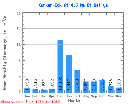
| Statistic | Jan | Feb | Mar | Apr | May | Jun | Jul | Aug | Sep | Oct | Nov | Dec | Annual |
|---|---|---|---|---|---|---|---|---|---|---|---|---|---|
| Mean | 1.09 | 0.92 | 0.82 | 0.89 | 13.10 | 9.42 | 5.79 | 2.81 | 2.83 | 3.12 | 1.78 | 1.31 | 3.67 |
| Standard Deviation | 0.16 | 0.12 | 0.11 | 0.24 | 4.21 | 3.15 | 2.27 | 0.44 | 0.97 | 1.39 | 0.24 | 0.16 | 0.13 |
| Min | 0.85 | 0.73 | 0.68 | 0.67 | 9.80 | 4.77 | 3.22 | 2.34 | 2.07 | 1.77 | 1.44 | 1.11 | 3.54 |
| Max | 1.28 | 1.04 | 0.92 | 1.30 | 19.10 | 11.40 | 8.72 | 3.34 | 4.22 | 4.64 | 2.10 | 1.54 | 3.83 |
| Coefficient of Variation | 0.15 | 0.13 | 0.13 | 0.27 | 0.32 | 0.33 | 0.39 | 0.16 | 0.34 | 0.44 | 0.13 | 0.12 | 0.04 |
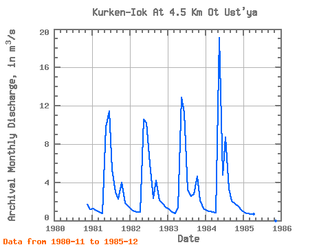
| Year | Jan | Feb | Mar | Apr | May | Jun | Jul | Aug | Sep | Oct | Nov | Dec | Annual | 1980 | 1.72 | 1.20 | 1981 | 1.28 | 1.04 | 0.90 | 0.78 | 9.80 | 11.40 | 5.35 | 2.97 | 2.27 | 3.95 | 1.80 | 1.54 | 3.59 | 1982 | 1.15 | 1.00 | 0.92 | 0.87 | 10.60 | 10.20 | 5.88 | 2.34 | 4.22 | 2.14 | 1.82 | 1.40 | 3.54 | 1983 | 1.15 | 0.87 | 0.74 | 1.30 | 12.90 | 11.30 | 3.22 | 2.58 | 2.76 | 4.64 | 2.10 | 1.22 | 3.73 | 1984 | 1.02 | 0.94 | 0.87 | 0.84 | 19.10 | 4.77 | 8.72 | 3.34 | 2.07 | 1.77 | 1.44 | 1.11 | 3.83 | 1985 | 0.85 | 0.73 | 0.68 | 0.67 | 1.38 |
|---|
 Return to R-Arctic Net Home Page