|
|
|||||||||||||||||
| Point ID: 8936 | Downloads | Plots | Site Data | Code: 70608 |
|
|
|||||||||||||||||
| Download | |
|---|---|
| Site Descriptor Information | Site Time Series Data |
| Link to all available data | |
|
|
| View: | Statistics | Time Series |
| Units: | mm |
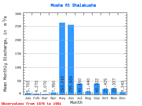
| Statistic | Jan | Feb | Mar | Apr | May | Jun | Jul | Aug | Sep | Oct | Nov | Dec | Annual |
|---|---|---|---|---|---|---|---|---|---|---|---|---|---|
| Mean | 5.70 | 4.27 | 3.07 | 7.95 | 263.01 | 255.82 | 40.65 | 11.44 | 40.32 | 21.43 | 23.34 | 9.24 | 43.68 |
| Standard Deviation | 5.08 | 4.43 | 3.19 | 8.10 | 184.37 | 202.56 | 36.29 | 5.49 | 35.13 | 6.24 | 26.21 | 7.44 | |
| Min | 1.63 | 1.00 | 0.65 | 0.75 | 3.04 | 80.50 | 13.30 | 7.19 | 9.09 | 12.10 | 7.91 | 3.34 | 43.68 |
| Max | 11.40 | 10.80 | 8.67 | 20.20 | 400.00 | 490.00 | 93.50 | 19.50 | 82.70 | 25.10 | 53.60 | 17.60 | 43.68 |
| Coefficient of Variation | 0.89 | 1.04 | 1.04 | 1.02 | 0.70 | 0.79 | 0.89 | 0.48 | 0.87 | 0.29 | 1.12 | 0.81 |
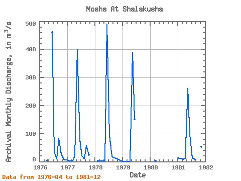
| Year | Jan | Feb | Mar | Apr | May | Jun | Jul | Aug | Sep | Oct | Nov | Dec | Annual | 1976 | 4.56 | 461.00 | 34.40 | 9.63 | 82.70 | 25.10 | 8.50 | 6.79 | 1977 | 4.08 | 2.38 | 1.84 | 20.20 | 400.00 | 80.50 | 21.40 | 9.44 | 55.60 | 24.60 | 1978 | 2.91 | 2.28 | 2.24 | 3.04 | 490.00 | 93.50 | 19.50 | 13.90 | 12.10 | 7.91 | 3.34 | 1979 | 1.63 | 1.00 | 0.65 | 0.75 | 388.00 | 152.00 | 1980 | 1.91 | 1981 | 11.40 | 10.80 | 8.67 | 12.00 | 261.00 | 95.60 | 13.30 | 7.19 | 9.09 | 23.90 | 53.60 | 17.60 | 43.68 |
|---|
 Return to R-Arctic Net Home Page