|
|
|||||||||||||||||
| Point ID: 8917 | Downloads | Plots | Site Data | Code: 70581 |
|
|
|||||||||||||||||
| Download | |
|---|---|
| Site Descriptor Information | Site Time Series Data |
| Link to all available data | |
|
|
| View: | Statistics | Time Series |
| Units: | mm |
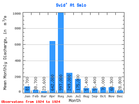
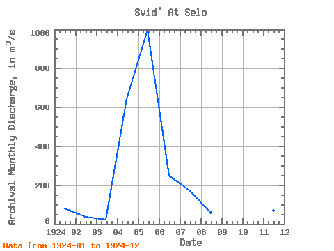
| Statistic | Jan | Feb | Mar | Apr | May | Jun | Jul | Aug | Sep | Oct | Nov | Dec | Annual |
|---|---|---|---|---|---|---|---|---|---|---|---|---|---|
| Mean | 81.70 | 38.70 | 23.60 | 642.00 | 997.00 | 249.00 | 175.00 | 57.40 | 55.40 | 70.00 | 68.30 | 28.80 | 207.24 |
| Standard Deviation | |||||||||||||
| Min | 81.70 | 38.70 | 23.60 | 642.00 | 997.00 | 249.00 | 175.00 | 57.40 | 55.40 | 70.00 | 68.30 | 28.80 | 207.24 |
| Max | 81.70 | 38.70 | 23.60 | 642.00 | 997.00 | 249.00 | 175.00 | 57.40 | 55.40 | 70.00 | 68.30 | 28.80 | 207.24 |
| Coefficient of Variation |
| Year | Jan | Feb | Mar | Apr | May | Jun | Jul | Aug | Sep | Oct | Nov | Dec | Annual | 1924 | 81.70 | 38.70 | 23.60 | 642.00 | 997.00 | 249.00 | 175.00 | 57.40 | 55.40 | 70.00 | 68.30 | 28.80 | 207.24 |
|---|
 Return to R-Arctic Net Home Page