|
|
|||||||||||||||||
| Point ID: 8902 | Downloads | Plots | Site Data | Code: 70561 |
|
|
|||||||||||||||||
| Download | |
|---|---|
| Site Descriptor Information | Site Time Series Data |
| Link to all available data | |
|
|
| View: | Statistics | Time Series |
| Units: | mm |
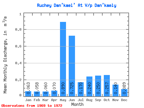
| Statistic | Jan | Feb | Mar | Apr | May | Jun | Jul | Aug | Sep | Oct | Nov | Dec | Annual |
|---|---|---|---|---|---|---|---|---|---|---|---|---|---|
| Mean | 0.06 | 0.06 | 0.06 | 0.07 | 0.89 | 0.72 | 0.17 | 0.24 | 0.25 | 0.26 | 0.14 | 0.09 | 0.25 |
| Standard Deviation | 0.01 | 0.01 | 0.01 | 0.04 | 0.33 | 0.53 | 0.06 | 0.17 | 0.17 | 0.05 | 0.02 | 0.01 | 0.04 |
| Min | 0.05 | 0.05 | 0.05 | 0.04 | 0.66 | 0.35 | 0.12 | 0.12 | 0.13 | 0.20 | 0.13 | 0.08 | 0.22 |
| Max | 0.08 | 0.07 | 0.06 | 0.10 | 1.12 | 1.10 | 0.24 | 0.36 | 0.37 | 0.30 | 0.16 | 0.10 | 0.27 |
| Coefficient of Variation | 0.18 | 0.18 | 0.11 | 0.54 | 0.36 | 0.73 | 0.37 | 0.71 | 0.68 | 0.20 | 0.13 | 0.09 | 0.14 |
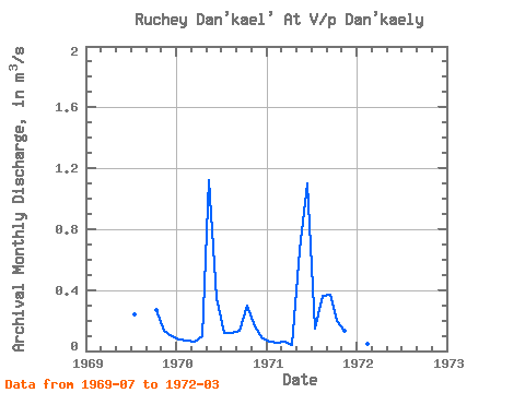
| Year | Jan | Feb | Mar | Apr | May | Jun | Jul | Aug | Sep | Oct | Nov | Dec | Annual | 1969 | 0.24 | 0.27 | 0.13 | 0.10 | 1970 | 0.08 | 0.07 | 0.06 | 0.10 | 1.12 | 0.35 | 0.12 | 0.12 | 0.13 | 0.30 | 0.16 | 0.08 | 0.22 | 1971 | 0.06 | 0.05 | 0.06 | 0.04 | 0.66 | 1.10 | 0.15 | 0.36 | 0.37 | 0.20 | 0.13 | 0.09 | 0.27 | 1972 | 0.05 | 0.05 | 0.05 |
|---|
 Return to R-Arctic Net Home Page