|
|
|||||||||||||||||
| Point ID: 8856 | Downloads | Plots | Site Data | Code: 70320 |
|
|
|||||||||||||||||
| Download | |
|---|---|
| Site Descriptor Information | Site Time Series Data |
| Link to all available data | |
|
|
| View: | Statistics | Time Series |
| Units: | mm |
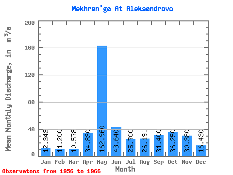
| Statistic | Jan | Feb | Mar | Apr | May | Jun | Jul | Aug | Sep | Oct | Nov | Dec | Annual |
|---|---|---|---|---|---|---|---|---|---|---|---|---|---|
| Mean | 12.34 | 11.20 | 10.58 | 34.83 | 162.96 | 43.64 | 25.70 | 26.19 | 31.40 | 36.25 | 30.38 | 16.43 | 35.67 |
| Standard Deviation | 1.88 | 1.69 | 1.14 | 36.47 | 64.72 | 15.36 | 10.37 | 23.68 | 21.11 | 17.45 | 11.14 | 3.86 | 9.09 |
| Min | 9.13 | 9.23 | 8.84 | 11.00 | 42.60 | 20.50 | 16.00 | 10.10 | 12.20 | 18.40 | 17.20 | 10.10 | 22.83 |
| Max | 16.00 | 14.40 | 12.90 | 133.00 | 264.00 | 68.60 | 50.20 | 83.80 | 74.80 | 80.50 | 53.00 | 22.40 | 49.26 |
| Coefficient of Variation | 0.15 | 0.15 | 0.11 | 1.05 | 0.40 | 0.35 | 0.40 | 0.90 | 0.67 | 0.48 | 0.37 | 0.23 | 0.26 |
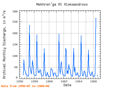
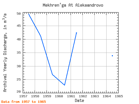
| Year | Jan | Feb | Mar | Apr | May | Jun | Jul | Aug | Sep | Oct | Nov | Dec | Annual | 1956 | 16.20 | 83.80 | 38.60 | 36.20 | 20.30 | 19.80 | 1957 | 13.40 | 12.80 | 10.20 | 14.50 | 235.00 | 54.80 | 33.90 | 19.60 | 43.40 | 80.50 | 53.00 | 20.00 | 49.26 | 1958 | 16.00 | 14.40 | 12.90 | 14.60 | 193.00 | 66.40 | 26.50 | 31.90 | 25.00 | 38.80 | 36.90 | 18.60 | 41.25 | 1959 | 12.60 | 11.60 | 11.50 | 18.80 | 132.00 | 37.40 | 19.10 | 10.10 | 14.00 | 27.50 | 17.20 | 10.10 | 26.82 | 1960 | 9.13 | 9.37 | 8.84 | 44.50 | 42.60 | 38.90 | 25.60 | 10.20 | 23.20 | 25.40 | 23.90 | 12.30 | 22.83 | 1961 | 11.70 | 10.30 | 10.90 | 11.00 | 196.00 | 40.90 | 20.00 | 57.90 | 74.80 | 38.00 | 21.80 | 14.90 | 42.35 | 1962 | 13.40 | 12.50 | 11.20 | 133.00 | 120.00 | 20.50 | 34.50 | 21.10 | 62.70 | 42.70 | 42.90 | 22.40 | 44.74 | 1963 | 13.50 | 11.70 | 10.70 | 42.80 | 133.00 | 30.10 | 50.20 | 14.20 | 15.00 | 18.40 | 26.50 | 15.90 | 31.83 | 1964 | 11.20 | 10.30 | 10.20 | 16.10 | 189.00 | 43.50 | 16.00 | 11.50 | 16.90 | 33.20 | 30.90 | 17.00 | 33.82 | 1965 | 11.60 | 9.80 | 9.65 | 30.90 | 125.00 | 35.30 | 22.90 | 15.10 | 12.20 | 21.80 | 30.40 | 13.30 | 28.16 | 1966 | 10.90 | 9.23 | 9.69 | 22.10 | 264.00 | 68.60 | 17.80 | 12.70 | 19.60 |
|---|
 Return to R-Arctic Net Home Page