|
|
|||||||||||||||||
| Point ID: 8810 | Downloads | Plots | Site Data | Code: 12308 |
|
|
|||||||||||||||||
| Download | |
|---|---|
| Site Descriptor Information | Site Time Series Data |
| Link to all available data | |
|
|
| View: | Statistics | Time Series |
| Units: | mm |
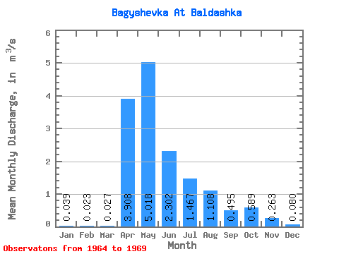
| Statistic | Jan | Feb | Mar | Apr | May | Jun | Jul | Aug | Sep | Oct | Nov | Dec | Annual |
|---|---|---|---|---|---|---|---|---|---|---|---|---|---|
| Mean | 0.04 | 0.02 | 0.03 | 3.91 | 5.02 | 2.30 | 1.47 | 1.11 | 0.49 | 0.59 | 0.26 | 0.08 | 1.17 |
| Standard Deviation | 0.06 | 0.04 | 0.05 | 3.13 | 3.16 | 1.09 | 2.27 | 1.77 | 0.50 | 0.42 | 0.13 | 0.06 | 0.58 |
| Min | 0.00 | 0.00 | 0.00 | 1.30 | 0.77 | 1.10 | 0.20 | 0.09 | 0.07 | 0.08 | 0.06 | 0.01 | 0.48 |
| Max | 0.14 | 0.10 | 0.12 | 9.88 | 9.80 | 4.25 | 6.05 | 4.66 | 1.47 | 1.11 | 0.37 | 0.16 | 1.89 |
| Coefficient of Variation | 1.43 | 1.72 | 1.72 | 0.80 | 0.63 | 0.47 | 1.54 | 1.59 | 1.02 | 0.71 | 0.48 | 0.78 | 0.49 |
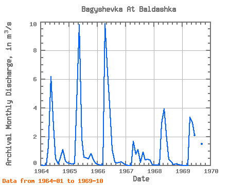
| Year | Jan | Feb | Mar | Apr | May | Jun | Jul | Aug | Sep | Oct | Nov | Dec | Annual | 1964 | 0.00 | 0.00 | 0.00 | 1.30 | 6.17 | 2.71 | 0.45 | 0.09 | 0.47 | 1.11 | 0.31 | 0.16 | 1.06 | 1965 | 0.14 | 0.10 | 0.12 | 4.37 | 9.80 | 1.86 | 0.57 | 0.53 | 0.44 | 0.82 | 0.35 | 0.12 | 1.60 | 1966 | 0.07 | 0.03 | 0.03 | 9.88 | 6.48 | 4.25 | 1.11 | 0.22 | 0.15 | 0.21 | 0.23 | 0.08 | 1.89 | 1967 | 0.00 | 0.00 | 0.00 | 1.65 | 0.77 | 1.10 | 0.20 | 0.92 | 0.37 | 0.40 | 0.37 | 0.03 | 0.48 | 1968 | 0.02 | 0.01 | 0.01 | 2.91 | 3.94 | 1.81 | 0.42 | 0.23 | 0.07 | 0.08 | 0.06 | 0.01 | 0.80 | 1969 | 0.00 | 0.00 | 0.00 | 3.34 | 2.95 | 2.08 | 6.05 | 4.66 | 1.47 | 0.92 |
|---|
 Return to R-Arctic Net Home Page