|
|
|||||||||||||||||
| Point ID: 8804 | Downloads | Plots | Site Data | Code: 12280 |
|
|
|||||||||||||||||
| Download | |
|---|---|
| Site Descriptor Information | Site Time Series Data |
| Link to all available data | |
|
|
| View: | Statistics | Time Series |
| Units: | mm |
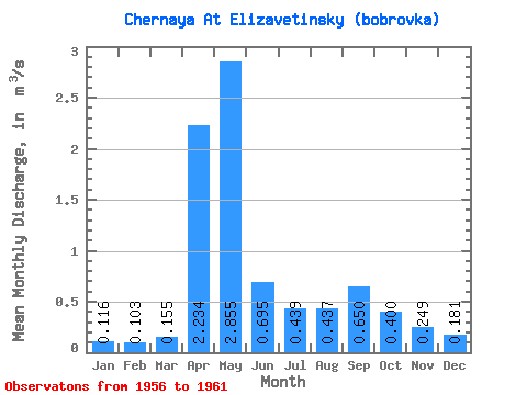
| Statistic | Jan | Feb | Mar | Apr | May | Jun | Jul | Aug | Sep | Oct | Nov | Dec | Annual |
|---|---|---|---|---|---|---|---|---|---|---|---|---|---|
| Mean | 0.12 | 0.10 | 0.15 | 2.23 | 2.85 | 0.69 | 0.44 | 0.44 | 0.65 | 0.40 | 0.25 | 0.18 | 0.71 |
| Standard Deviation | 0.05 | 0.04 | 0.12 | 0.76 | 1.59 | 0.80 | 0.50 | 0.64 | 1.06 | 0.42 | 0.18 | 0.12 | 0.19 |
| Min | 0.04 | 0.05 | 0.05 | 1.54 | 0.76 | 0.14 | 0.13 | 0.12 | 0.09 | 0.13 | 0.06 | 0.04 | 0.54 |
| Max | 0.16 | 0.16 | 0.37 | 3.21 | 4.09 | 2.30 | 1.41 | 1.74 | 2.78 | 1.25 | 0.52 | 0.36 | 1.05 |
| Coefficient of Variation | 0.44 | 0.42 | 0.76 | 0.34 | 0.56 | 1.15 | 1.14 | 1.47 | 1.62 | 1.06 | 0.73 | 0.65 | 0.27 |
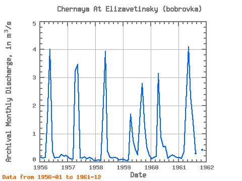
| Year | Jan | Feb | Mar | Apr | May | Jun | Jul | Aug | Sep | Oct | Nov | Dec | Annual | 1956 | 0.16 | 0.14 | 0.15 | 1.54 | 4.01 | 0.37 | 0.14 | 0.15 | 0.16 | 0.25 | 0.19 | 0.23 | 0.62 | 1957 | 0.16 | 0.10 | 0.10 | 3.21 | 3.47 | 0.14 | 0.13 | 0.17 | 0.09 | 0.16 | 0.11 | 0.04 | 0.66 | 1958 | 0.04 | 0.06 | 0.05 | 1.68 | 3.93 | 0.38 | 0.16 | 0.14 | 0.15 | 0.13 | 0.06 | 0.07 | 0.57 | 1959 | 0.08 | 0.05 | 0.07 | 1.69 | 0.76 | 0.45 | 0.24 | 1.74 | 2.78 | 1.25 | 0.52 | 0.22 | 0.82 | 1960 | 0.10 | 0.16 | 0.19 | 3.14 | 0.87 | 0.53 | 0.55 | 0.12 | 0.18 | 0.24 | 0.19 | 0.16 | 0.54 | 1961 | 0.16 | 0.11 | 0.37 | 2.14 | 4.09 | 2.30 | 1.41 | 0.30 | 0.54 | 0.37 | 0.42 | 0.36 | 1.05 |
|---|
 Return to R-Arctic Net Home Page