|
|
|||||||||||||||||
| Point ID: 8768 | Downloads | Plots | Site Data | Code: 12069 |
|
|
|||||||||||||||||
| Download | |
|---|---|
| Site Descriptor Information | Site Time Series Data |
| Link to all available data | |
|
|
| View: | Statistics | Time Series |
| Units: | mm |
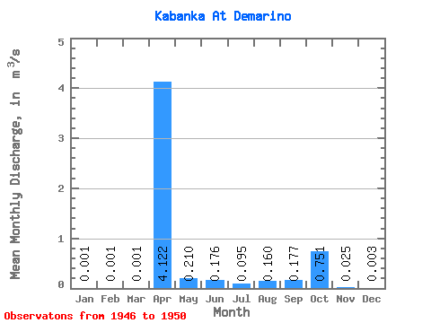
| Statistic | Jan | Feb | Mar | Apr | May | Jun | Jul | Aug | Sep | Oct | Nov | Dec | Annual |
|---|---|---|---|---|---|---|---|---|---|---|---|---|---|
| Mean | 0.00 | 0.00 | 0.00 | 4.12 | 0.21 | 0.18 | 0.10 | 0.16 | 0.18 | 0.75 | 0.03 | 0.00 | 0.48 |
| Standard Deviation | 0.00 | 0.00 | 0.00 | 2.62 | 0.13 | 0.31 | 0.14 | 0.29 | 0.25 | 1.55 | 0.03 | 0.00 | 0.35 |
| Min | 0.00 | 0.00 | 0.00 | 1.19 | 0.05 | 0.01 | 0.00 | 0.00 | 0.00 | 0.00 | 0.00 | 0.00 | 0.11 |
| Max | 0.00 | 0.00 | 0.00 | 7.21 | 0.37 | 0.72 | 0.33 | 0.68 | 0.60 | 3.52 | 0.07 | 0.01 | 0.95 |
| Coefficient of Variation | 1.41 | 1.37 | 1.37 | 0.64 | 0.63 | 1.75 | 1.48 | 1.82 | 1.41 | 2.06 | 1.18 | 1.11 | 0.73 |
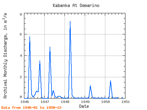
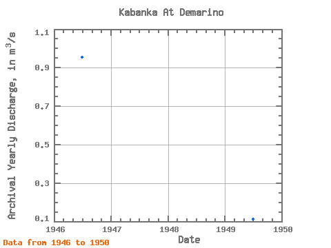
| Year | Jan | Feb | Mar | Apr | May | Jun | Jul | Aug | Sep | Oct | Nov | Dec | Annual | 1946 | 0.00 | 0.00 | 0.00 | 5.77 | 0.37 | 0.11 | 0.33 | 0.68 | 0.60 | 3.52 | 0.07 | 0.00 | 0.95 | 1947 | 0.00 | 0.00 | 0.00 | 4.80 | 0.20 | 0.72 | 0.12 | 0.06 | 0.20 | 0.20 | 0.04 | 0.01 | 0.53 | 1948 | 0.00 | 0.00 | 0.00 | 7.21 | 0.31 | 0.02 | 0.00 | 0.00 | 0.00 | 0.01 | 0.01 | 0.00 | 0.63 | 1949 | 0.00 | 0.00 | 0.00 | 1.19 | 0.12 | 0.01 | 0.00 | 0.00 | 0.00 | 0.00 | 0.00 | 0.00 | 0.11 | 1950 | 0.00 | 0.00 | 0.00 | 1.64 | 0.05 | 0.01 | 0.02 | 0.06 | 0.08 | 0.03 | 0.01 | 0.00 | 0.16 |
|---|
 Return to R-Arctic Net Home Page