|
|
|||||||||||||||||
| Point ID: 869 | Downloads | Plots | Site Data | Code: 07EE005 |
|
|
|||||||||||||||||
| Download | |
|---|---|
| Site Descriptor Information | Site Time Series Data |
| Link to all available data | |
|
|
| View: | Statistics | Time Series |
| Units: | mm |
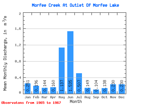
| Statistic | Jan | Feb | Mar | Apr | May | Jun | Jul | Aug | Sep | Oct | Nov | Dec | Annual |
|---|---|---|---|---|---|---|---|---|---|---|---|---|---|
| Mean | 0.25 | 0.20 | 0.14 | 0.16 | 1.14 | 1.54 | 0.51 | 0.15 | 0.10 | 0.14 | 0.23 | 0.23 | 0.36 |
| Standard Deviation | 0.08 | 0.15 | 0.09 | 0.02 | 0.32 | 0.08 | 0.16 | 0.02 | 0.01 | 0.02 | 0.02 | 0.05 | |
| Min | 0.19 | 0.09 | 0.08 | 0.14 | 0.91 | 1.48 | 0.40 | 0.13 | 0.10 | 0.12 | 0.22 | 0.19 | 0.36 |
| Max | 0.31 | 0.30 | 0.21 | 0.17 | 1.36 | 1.59 | 0.62 | 0.17 | 0.11 | 0.16 | 0.24 | 0.27 | 0.36 |
| Coefficient of Variation | 0.34 | 0.76 | 0.62 | 0.13 | 0.28 | 0.05 | 0.31 | 0.16 | 0.10 | 0.15 | 0.07 | 0.22 |
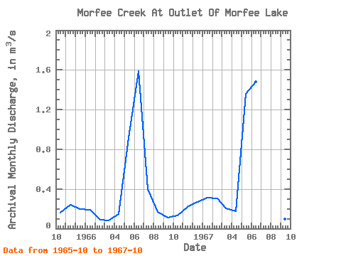
| Year | Jan | Feb | Mar | Apr | May | Jun | Jul | Aug | Sep | Oct | Nov | Dec | Annual | 1965 | 0.16 | 0.24 | 0.19 | 1966 | 0.19 | 0.09 | 0.08 | 0.14 | 0.91 | 1.59 | 0.40 | 0.17 | 0.11 | 0.13 | 0.22 | 0.27 | 0.36 | 1967 | 0.31 | 0.30 | 0.21 | 0.17 | 1.36 | 1.48 | 0.62 | 0.13 | 0.10 | 0.12 |
|---|
 Return to R-Arctic Net Home Page