|
|
|||||||||||||||||
| Point ID: 8628 | Downloads | Plots | Site Data | Code: 11294 |
|
|
|||||||||||||||||
| Download | |
|---|---|
| Site Descriptor Information | Site Time Series Data |
| Link to all available data | |
|
|
| View: | Statistics | Time Series |
| Units: | mm |
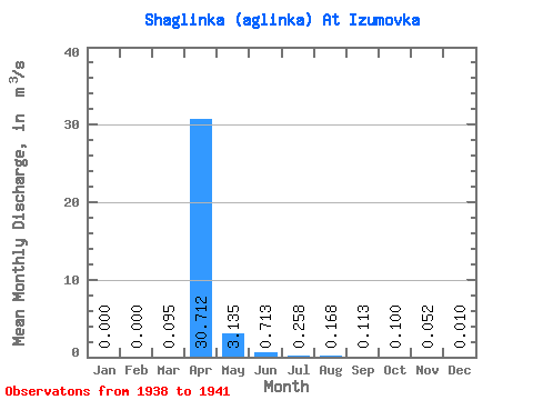
| Statistic | Jan | Feb | Mar | Apr | May | Jun | Jul | Aug | Sep | Oct | Nov | Dec | Annual |
|---|---|---|---|---|---|---|---|---|---|---|---|---|---|
| Mean | 0.00 | 0.00 | 0.10 | 30.71 | 3.13 | 0.71 | 0.26 | 0.17 | 0.11 | 0.10 | 0.05 | 0.01 | 2.95 |
| Standard Deviation | 0.00 | 0.00 | 0.19 | 59.53 | 4.72 | 0.28 | 0.10 | 0.10 | 0.06 | 0.06 | 0.04 | 0.02 | 5.38 |
| Min | 0.00 | 0.00 | 0.00 | 0.04 | 0.28 | 0.41 | 0.15 | 0.06 | 0.04 | 0.04 | 0.02 | 0.00 | 0.15 |
| Max | 0.00 | 0.00 | 0.38 | 120.00 | 10.20 | 1.08 | 0.36 | 0.30 | 0.17 | 0.17 | 0.11 | 0.04 | 11.02 |
| Coefficient of Variation | 2.00 | 1.94 | 1.51 | 0.40 | 0.38 | 0.60 | 0.53 | 0.57 | 0.81 | 2.00 | 1.83 |
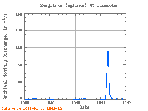
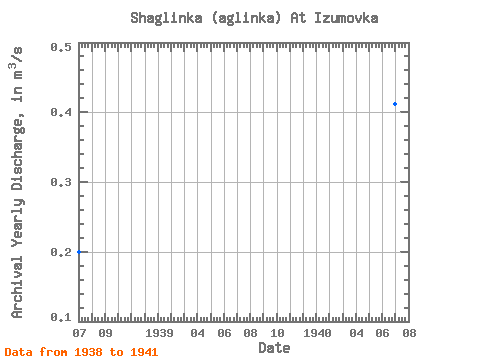
| Year | Jan | Feb | Mar | Apr | May | Jun | Jul | Aug | Sep | Oct | Nov | Dec | Annual | 1938 | 0.00 | 0.00 | 0.00 | 0.04 | 0.92 | 0.76 | 0.32 | 0.14 | 0.09 | 0.07 | 0.06 | 0.00 | 0.20 | 1939 | 0.00 | 0.00 | 0.38 | 0.46 | 0.28 | 0.41 | 0.15 | 0.06 | 0.04 | 0.04 | 0.02 | 0.00 | 0.15 | 1940 | 0.00 | 0.00 | 0.00 | 2.35 | 1.14 | 0.60 | 0.20 | 0.17 | 0.17 | 0.17 | 0.11 | 0.04 | 0.41 | 1941 | 0.00 | 0.00 | 0.00 | 120.00 | 10.20 | 1.08 | 0.36 | 0.30 | 0.15 | 0.12 | 0.02 | 0.00 | 11.02 |
|---|
 Return to R-Arctic Net Home Page