|
|
|||||||||||||||||
| Point ID: 8615 | Downloads | Plots | Site Data | Code: 11235 |
|
|
|||||||||||||||||
| Download | |
|---|---|
| Site Descriptor Information | Site Time Series Data |
| Link to all available data | |
|
|
| View: | Statistics | Time Series |
| Units: | mm |
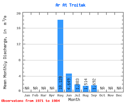
| Statistic | Jan | Feb | Mar | Apr | May | Jun | Jul | Aug | Sep | Oct | Nov | Dec | Annual |
|---|---|---|---|---|---|---|---|---|---|---|---|---|---|
| Mean | 18.13 | 4.65 | 1.88 | 1.51 | 1.69 | ||||||||
| Standard Deviation | 23.82 | 4.04 | 0.93 | 0.42 | 0.70 | ||||||||
| Min | 1.74 | 1.09 | 0.77 | 1.00 | 0.87 | ||||||||
| Max | 77.20 | 15.80 | 4.52 | 2.59 | 2.75 | ||||||||
| Coefficient of Variation | 1.31 | 0.87 | 0.50 | 0.28 | 0.41 |
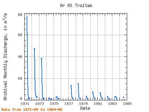
| Year | Jan | Feb | Mar | Apr | May | Jun | Jul | Aug | Sep | Oct | Nov | Dec | Annual | 1971 | 77.20 | 15.80 | 0.98 | 1.21 | 1.81 | 1972 | 47.30 | 9.80 | 4.52 | 2.59 | 2.75 | 1973 | 38.20 | 6.92 | 0.98 | 1.66 | 1.70 | 1974 | 1.74 | 1.09 | 0.77 | 1.00 | 0.87 | 1975 | 2.62 | 2.99 | 1.99 | 1.00 | 1.33 | 1977 | 13.20 | 3.31 | 1.95 | 1.67 | 1978 | 15.10 | 2.34 | 1.89 | 1.65 | 1979 | 3.36 | 1.57 | 1.36 | 1980 | 7.29 | 3.30 | 1.94 | 1.72 | 1981 | 6.45 | 2.92 | 1.77 | 1.50 | 1982 | 2.92 | 1.77 | 1.50 | 1.04 | 1983 | 2.76 | 3.42 | 2.31 | 1.64 | 1984 | 2.76 | 3.42 | 2.31 | 1.64 |
|---|
 Return to R-Arctic Net Home Page