|
|
|||||||||||||||||
| Point ID: 860 | Downloads | Plots | Site Data | Code: 07EC001 |
|
|
|||||||||||||||||
| Download | |
|---|---|
| Site Descriptor Information | Site Time Series Data |
| Link to all available data | |
|
|
| View: | Statistics | Time Series |
| Units: | mm |
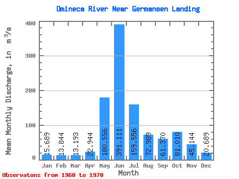
| Statistic | Jan | Feb | Mar | Apr | May | Jun | Jul | Aug | Sep | Oct | Nov | Dec | Annual |
|---|---|---|---|---|---|---|---|---|---|---|---|---|---|
| Mean | 15.69 | 13.84 | 13.19 | 22.94 | 180.56 | 391.11 | 159.56 | 72.99 | 61.37 | 81.01 | 45.14 | 20.69 | 90.17 |
| Standard Deviation | 2.82 | 2.56 | 2.43 | 5.78 | 61.55 | 93.54 | 48.93 | 32.61 | 22.44 | 15.86 | 17.55 | 4.88 | 10.91 |
| Min | 12.40 | 11.10 | 9.73 | 14.20 | 104.00 | 291.00 | 77.00 | 35.80 | 33.00 | 61.30 | 31.20 | 15.00 | 75.58 |
| Max | 20.80 | 18.70 | 17.60 | 31.60 | 280.00 | 604.00 | 225.00 | 149.00 | 111.00 | 114.00 | 88.80 | 29.40 | 112.57 |
| Coefficient of Variation | 0.18 | 0.18 | 0.18 | 0.25 | 0.34 | 0.24 | 0.31 | 0.45 | 0.37 | 0.20 | 0.39 | 0.24 | 0.12 |
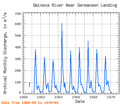
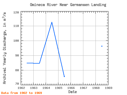
| Year | Jan | Feb | Mar | Apr | May | Jun | Jul | Aug | Sep | Oct | Nov | Dec | Annual | 1960 | 58.00 | 92.20 | 1961 | 16.30 | 22.30 | 280.00 | 381.00 | 106.00 | 35.80 | 55.40 | 69.60 | 33.30 | 15.00 | 1962 | 17.00 | 16.10 | 11.90 | 19.30 | 128.00 | 315.00 | 198.00 | 81.30 | 44.30 | 76.00 | 88.80 | 21.30 | 84.75 | 1963 | 18.70 | 18.70 | 17.60 | 31.60 | 201.00 | 291.00 | 178.00 | 66.20 | 49.80 | 75.60 | 37.80 | 29.40 | 84.62 | 1964 | 20.80 | 14.70 | 13.60 | 18.10 | 106.00 | 604.00 | 225.00 | 149.00 | 51.70 | 96.80 | 34.40 | 16.70 | 112.57 | 1965 | 14.90 | 13.60 | 12.20 | 14.20 | 104.00 | 370.00 | 171.00 | 49.50 | 33.00 | 66.30 | 41.50 | 16.80 | 75.58 | 1966 | 13.40 | 12.20 | 11.40 | 21.30 | 178.00 | 398.00 | 181.00 | 79.30 | 82.00 | 61.30 | 44.00 | 18.10 | 91.67 | 1967 | 13.50 | 11.50 | 9.73 | 26.20 | 163.00 | 453.00 | 114.00 | 50.50 | 52.90 | 114.00 | 43.90 | 26.50 | 89.89 | 1968 | 16.80 | 15.20 | 15.00 | 22.50 | 225.00 | 383.00 | 186.00 | 64.50 | 75.60 | 77.50 | 51.40 | 23.40 | 96.33 | 1969 | 12.40 | 11.10 | 11.70 | 31.00 | 240.00 | 325.00 | 77.00 | 80.80 | 111.00 | 80.80 | 31.20 | 19.00 | 85.92 | 1970 | 13.70 | 11.50 | 12.50 |
|---|
 Return to R-Arctic Net Home Page