|
|
|||||||||||||||||
| Point ID: 8544 | Downloads | Plots | Site Data | Code: 11020 |
|
|
|||||||||||||||||
| Download | |
|---|---|
| Site Descriptor Information | Site Time Series Data |
| Link to all available data | |
|
|
| View: | Statistics | Time Series |
| Units: | mm |
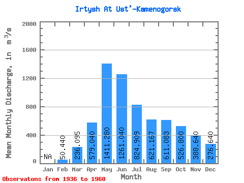
| Statistic | Jan | Feb | Mar | Apr | May | Jun | Jul | Aug | Sep | Oct | Nov | Dec | Annual |
|---|---|---|---|---|---|---|---|---|---|---|---|---|---|
| Mean | 50.44 | 236.09 | 579.04 | 1411.28 | 1261.04 | 824.91 | 621.17 | 611.08 | 526.80 | 388.64 | 276.64 | ||
| Standard Deviation | 30.82 | 53.10 | 238.35 | 353.38 | 389.07 | 211.95 | 209.71 | 159.37 | 147.05 | 120.08 | 65.63 | ||
| Min | 2.00 | 144.00 | 90.00 | 694.00 | 494.00 | 399.00 | 130.00 | 314.00 | 210.00 | 224.00 | 178.00 | ||
| Max | 93.00 | 343.00 | 993.00 | 2000.00 | 1890.00 | 1180.00 | 973.00 | 972.00 | 886.00 | 697.00 | 445.00 | ||
| Coefficient of Variation | 0.61 | 0.23 | 0.41 | 0.25 | 0.31 | 0.26 | 0.34 | 0.26 | 0.28 | 0.31 | 0.24 |
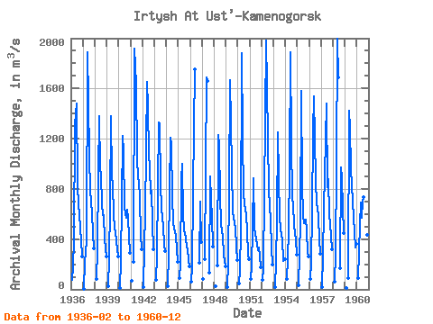
| Year | Jan | Feb | Mar | Apr | May | Jun | Jul | Aug | Sep | Oct | Nov | Dec | Annual | 1936 | 75.00 | 174.00 | 400.00 | 1310.00 | 1480.00 | 839.00 | 663.00 | 606.00 | 480.00 | 388.00 | 265.00 | 1937 | 2.00 | 216.00 | 380.00 | 1890.00 | 1510.00 | 1050.00 | 800.00 | 685.00 | 611.00 | 439.00 | 325.00 | 1938 | 82.00 | 319.00 | 908.00 | 1380.00 | 971.00 | 898.00 | 684.00 | 591.00 | 588.00 | 396.00 | 263.00 | 1939 | 26.00 | 243.00 | 674.00 | 1380.00 | 903.00 | 838.00 | 591.00 | 488.00 | 455.00 | 321.00 | 261.00 | 1940 | 12.00 | 236.00 | 700.00 | 1220.00 | 1090.00 | 652.00 | 568.00 | 635.00 | 561.00 | 417.00 | 288.00 | 1941 | 71.00 | 220.00 | 1920.00 | 1640.00 | 1050.00 | 879.00 | 864.00 | 724.00 | 435.00 | 316.00 | 1942 | 16.00 | 343.00 | 601.00 | 1650.00 | 1450.00 | 1070.00 | 973.00 | 761.00 | 785.00 | 527.00 | 319.00 | 1943 | 76.00 | 268.00 | 816.00 | 1330.00 | 1320.00 | 832.00 | 653.00 | 557.00 | 509.00 | 349.00 | 308.00 | 1944 | 23.00 | 281.00 | 801.00 | 1210.00 | 1150.00 | 733.00 | 536.00 | 482.00 | 429.00 | 318.00 | 216.00 | 1945 | 93.00 | 201.00 | 873.00 | 1000.00 | 589.00 | 480.00 | 414.00 | 336.00 | 325.00 | 235.00 | 183.00 | 1946 | 60.00 | 176.00 | 769.00 | 1290.00 | 1750.00 | 210.00 | 697.00 | 379.00 | 1947 | 79.00 | 240.00 | 1690.00 | 1660.00 | 130.00 | 902.00 | 711.00 | 570.00 | 340.00 | 1948 | 26.00 | 190.00 | 1230.00 | 1140.00 | 740.00 | 524.00 | 460.00 | 425.00 | 278.00 | 180.00 | 1949 | 16.00 | 208.00 | 802.00 | 1670.00 | 1330.00 | 954.00 | 614.00 | 579.00 | 483.00 | 337.00 | 232.00 | 1950 | 45.00 | 144.00 | 478.00 | 1880.00 | 1220.00 | 754.00 | 688.00 | 592.00 | 467.00 | 271.00 | 238.00 | 1951 | 86.00 | 183.00 | 485.00 | 882.00 | 494.00 | 399.00 | 357.00 | 314.00 | 332.00 | 270.00 | 178.00 | 1952 | 73.00 | 171.00 | 753.00 | 1980.00 | 1630.00 | 1180.00 | 806.00 | 655.00 | 557.00 | 324.00 | 199.00 | 1953 | 21.00 | 220.00 | 551.00 | 1250.00 | 893.00 | 567.00 | 486.00 | 424.00 | 407.00 | 224.00 | 239.00 | 1954 | 79.00 | 246.00 | 462.00 | 986.00 | 1890.00 | 1180.00 | 727.00 | 674.00 | 509.00 | 390.00 | 277.00 | 1955 | 34.00 | 282.00 | 529.00 | 1580.00 | 845.00 | 591.00 | 527.00 | 555.00 | 468.00 | 293.00 | 265.00 | 1956 | 84.00 | 208.00 | 610.00 | 1250.00 | 1540.00 | 872.00 | 667.00 | 662.00 | 567.00 | 399.00 | 282.00 | 1957 | 20.00 | 260.00 | 642.00 | 1190.00 | 1480.00 | 811.00 | 880.00 | 592.00 | 521.00 | 424.00 | 317.00 | 1958 | 60.00 | 285.00 | 993.00 | 2000.00 | 1690.00 | 170.00 | 972.00 | 886.00 | 651.00 | 445.00 | 1959 | 10.00 | 90.00 | 1420.00 | 1290.00 | 957.00 | 833.00 | 689.00 | 580.00 | 331.00 | 363.00 | 1960 | 92.00 | 294.00 | 509.00 | 694.00 | 571.00 | 701.00 | 738.00 | 591.00 | 580.00 | 432.00 | 238.00 |
|---|
 Return to R-Arctic Net Home Page