|
|
|||||||||||||||||
| Point ID: 8543 | Downloads | Plots | Site Data | Code: 11018 |
|
|
|||||||||||||||||
| Download | |
|---|---|
| Site Descriptor Information | Site Time Series Data |
| Link to all available data | |
|
|
| View: | Statistics | Time Series |
| Units: | mm |
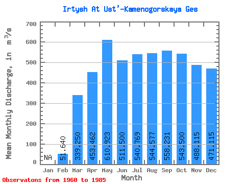
| Statistic | Jan | Feb | Mar | Apr | May | Jun | Jul | Aug | Sep | Oct | Nov | Dec | Annual |
|---|---|---|---|---|---|---|---|---|---|---|---|---|---|
| Mean | 51.64 | 339.25 | 453.46 | 610.92 | 511.50 | 540.77 | 544.58 | 558.23 | 543.50 | 488.12 | 471.12 | ||
| Standard Deviation | 27.44 | 103.14 | 269.94 | 192.81 | 94.72 | 83.99 | 96.50 | 106.02 | 92.43 | 106.70 | 153.81 | ||
| Min | 2.00 | 226.00 | 50.00 | 239.00 | 270.00 | 377.00 | 379.00 | 377.00 | 382.00 | 329.00 | 238.00 | ||
| Max | 90.00 | 657.00 | 919.00 | 968.00 | 741.00 | 747.00 | 738.00 | 802.00 | 768.00 | 724.00 | 847.00 | ||
| Coefficient of Variation | 0.53 | 0.30 | 0.59 | 0.32 | 0.18 | 0.15 | 0.18 | 0.19 | 0.17 | 0.22 | 0.33 |
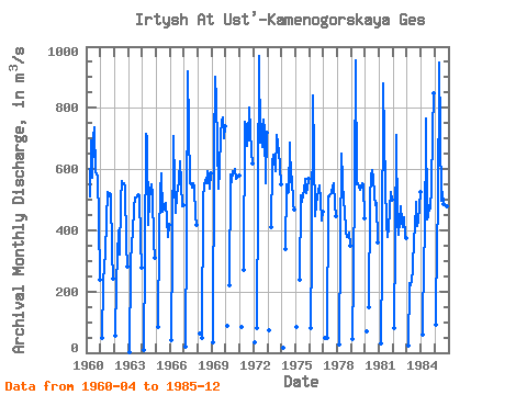
| Year | Jan | Feb | Mar | Apr | May | Jun | Jul | Aug | Sep | Oct | Nov | Dec | Annual | 1960 | 509.00 | 694.00 | 571.00 | 701.00 | 738.00 | 591.00 | 580.00 | 432.00 | 238.00 | 1961 | 50.00 | 226.00 | 284.00 | 319.00 | 436.00 | 524.00 | 509.00 | 520.00 | 516.00 | 329.00 | 242.00 | 1962 | 55.00 | 227.00 | 400.00 | 320.00 | 497.00 | 562.00 | 551.00 | 555.00 | 544.00 | 353.00 | 281.00 | 1963 | 2.00 | 292.00 | 356.00 | 397.00 | 472.00 | 508.00 | 508.00 | 518.00 | 512.00 | 368.00 | 278.00 | 1964 | 8.00 | 313.00 | 714.00 | 700.00 | 419.00 | 501.00 | 528.00 | 551.00 | 518.00 | 363.00 | 309.00 | 1965 | 84.00 | 384.00 | 524.00 | 585.00 | 462.00 | 473.00 | 483.00 | 491.00 | 437.00 | 377.00 | 417.00 | 1966 | 40.00 | 350.00 | 709.00 | 551.00 | 458.00 | 516.00 | 560.00 | 625.00 | 553.00 | 480.00 | 481.00 | 1967 | 19.00 | 396.00 | 919.00 | 738.00 | 554.00 | 553.00 | 538.00 | 554.00 | 544.00 | 447.00 | 417.00 | 1968 | 64.00 | 50.00 | 507.00 | 546.00 | 565.00 | 555.00 | 593.00 | 563.00 | 537.00 | 585.00 | 1969 | 34.00 | 657.00 | 902.00 | 821.00 | 537.00 | 598.00 | 711.00 | 753.00 | 768.00 | 702.00 | 741.00 | 1970 | 88.00 | 220.00 | 583.00 | 557.00 | 592.00 | 587.00 | 602.00 | 568.00 | 575.00 | 580.00 | 1971 | 86.00 | 270.00 | 755.00 | 741.00 | 674.00 | 705.00 | 802.00 | 727.00 | 655.00 | 620.00 | 1972 | 33.00 | 80.00 | 968.00 | 685.00 | 747.00 | 673.00 | 762.00 | 725.00 | 553.00 | 718.00 | 1973 | 72.00 | 410.00 | 617.00 | 647.00 | 631.00 | 594.00 | 710.00 | 654.00 | 612.00 | 549.00 | 1974 | 16.00 | 340.00 | 550.00 | 522.00 | 525.00 | 685.00 | 559.00 | 575.00 | 486.00 | 468.00 | 1975 | 83.00 | 240.00 | 513.00 | 493.00 | 519.00 | 527.00 | 569.00 | 520.00 | 537.00 | 567.00 | 1976 | 82.00 | 339.00 | 841.00 | 649.00 | 446.00 | 487.00 | 511.00 | 545.00 | 496.00 | 432.00 | 459.00 | 1977 | 50.00 | 50.00 | 510.00 | 510.00 | 518.00 | 520.00 | 544.00 | 552.00 | 486.00 | 447.00 | 1978 | 26.00 | 355.00 | 650.00 | 565.00 | 491.00 | 471.00 | 395.00 | 377.00 | 382.00 | 391.00 | 351.00 | 1979 | 44.00 | 251.00 | 564.00 | 955.00 | 551.00 | 552.00 | 534.00 | 544.00 | 554.00 | 549.00 | 438.00 | 1980 | 70.00 | 150.00 | 504.00 | 575.00 | 598.00 | 572.00 | 513.00 | 483.00 | 489.00 | 362.00 | 1981 | 32.00 | 310.00 | 881.00 | 703.00 | 545.00 | 423.00 | 379.00 | 407.00 | 467.00 | 525.00 | 500.00 | 1982 | 80.00 | 372.00 | 712.00 | 428.00 | 384.00 | 478.00 | 429.00 | 412.00 | 444.00 | 380.00 | 375.00 | 1983 | 24.00 | 229.00 | 221.00 | 239.00 | 270.00 | 377.00 | 400.00 | 493.00 | 415.00 | 432.00 | 526.00 | 1984 | 59.00 | 335.00 | 348.00 | 765.00 | 435.00 | 442.00 | 483.00 | 470.00 | 537.00 | 724.00 | 847.00 | 1985 | 90.00 | 392.00 | 446.00 | 948.00 | 495.00 | 525.00 | 484.00 | 454.00 | 497.00 | 477.00 | 453.00 |
|---|
 Return to R-Arctic Net Home Page