|
|
|||||||||||||||||
| Point ID: 8542 | Downloads | Plots | Site Data | Code: 11010 |
|
|
|||||||||||||||||
| Download | |
|---|---|
| Site Descriptor Information | Site Time Series Data |
| Link to all available data | |
|
|
| View: | Statistics | Time Series |
| Units: | mm |
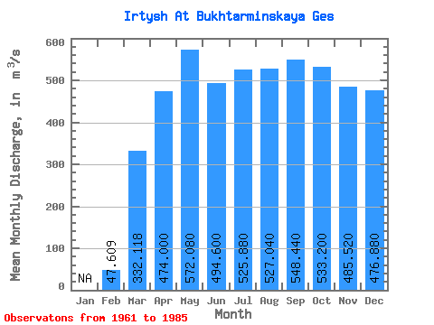
| Statistic | Jan | Feb | Mar | Apr | May | Jun | Jul | Aug | Sep | Oct | Nov | Dec | Annual |
|---|---|---|---|---|---|---|---|---|---|---|---|---|---|
| Mean | 47.61 | 332.12 | 474.00 | 572.08 | 494.60 | 525.88 | 527.04 | 548.44 | 533.20 | 485.52 | 476.88 | ||
| Standard Deviation | 26.24 | 97.52 | 283.04 | 198.28 | 93.39 | 74.85 | 83.80 | 102.10 | 90.62 | 102.89 | 147.83 | ||
| Min | 1.00 | 213.00 | 40.00 | 183.00 | 239.00 | 375.00 | 384.00 | 370.00 | 382.00 | 320.00 | 229.00 | ||
| Max | 99.00 | 638.00 | 994.00 | 915.00 | 692.00 | 713.00 | 694.00 | 783.00 | 754.00 | 732.00 | 848.00 | ||
| Coefficient of Variation | 0.55 | 0.29 | 0.60 | 0.35 | 0.19 | 0.14 | 0.16 | 0.19 | 0.17 | 0.21 | 0.31 |
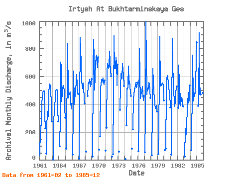
| Year | Jan | Feb | Mar | Apr | May | Jun | Jul | Aug | Sep | Oct | Nov | Dec | Annual | 1961 | 33.00 | 213.00 | 217.00 | 279.00 | 412.00 | 482.00 | 498.00 | 498.00 | 495.00 | 320.00 | 229.00 | 1962 | 46.00 | 219.00 | 348.00 | 312.00 | 472.00 | 548.00 | 523.00 | 539.00 | 535.00 | 375.00 | 276.00 | 1963 | 1.00 | 279.00 | 351.00 | 376.00 | 454.00 | 497.00 | 503.00 | 508.00 | 500.00 | 359.00 | 279.00 | 1964 | 99.00 | 305.00 | 703.00 | 673.00 | 422.00 | 489.00 | 516.00 | 537.00 | 503.00 | 368.00 | 303.00 | 1965 | 79.00 | 376.00 | 509.00 | 842.00 | 447.00 | 488.00 | 473.00 | 488.00 | 418.00 | 369.00 | 402.00 | 1966 | 38.00 | 330.00 | 639.00 | 400.00 | 438.00 | 508.00 | 557.00 | 616.00 | 537.00 | 480.00 | 476.00 | 1967 | 10.00 | 380.00 | 883.00 | 706.00 | 557.00 | 546.00 | 514.00 | 553.00 | 530.00 | 439.00 | 408.00 | 1968 | 60.00 | 461.00 | 541.00 | 556.00 | 555.00 | 579.00 | 552.00 | 528.00 | 582.00 | 1969 | 23.00 | 638.00 | 865.00 | 722.00 | 505.00 | 603.00 | 694.00 | 735.00 | 754.00 | 664.00 | 741.00 | 1970 | 73.00 | 170.00 | 525.00 | 539.00 | 579.00 | 561.00 | 590.00 | 556.00 | 543.00 | 573.00 | 1971 | 68.00 | 230.00 | 632.00 | 692.00 | 662.00 | 670.00 | 783.00 | 709.00 | 640.00 | 605.00 | 1972 | 22.00 | 40.00 | 893.00 | 657.00 | 713.00 | 658.00 | 739.00 | 700.00 | 536.00 | 687.00 | 1973 | 58.00 | 360.00 | 528.00 | 621.00 | 599.00 | 585.00 | 692.00 | 647.00 | 610.00 | 531.00 | 1974 | 6.00 | 250.00 | 516.00 | 512.00 | 527.00 | 677.00 | 548.00 | 569.00 | 489.00 | 462.00 | 1975 | 81.00 | 220.00 | 454.00 | 462.00 | 514.00 | 515.00 | 556.00 | 522.00 | 528.00 | 558.00 | 1976 | 64.00 | 345.00 | 805.00 | 605.00 | 441.00 | 484.00 | 495.00 | 528.00 | 476.00 | 428.00 | 462.00 | 1977 | 56.00 | 318.00 | 994.00 | 472.00 | 519.00 | 509.00 | 511.00 | 559.00 | 545.00 | 495.00 | 446.00 | 1978 | 33.00 | 361.00 | 659.00 | 569.00 | 481.00 | 456.00 | 402.00 | 370.00 | 382.00 | 393.00 | 350.00 | 1979 | 43.00 | 252.00 | 544.00 | 889.00 | 533.00 | 552.00 | 537.00 | 540.00 | 552.00 | 541.00 | 429.00 | 1980 | 70.00 | 80.00 | 495.00 | 582.00 | 609.00 | 565.00 | 521.00 | 486.00 | 482.00 | 377.00 | 1981 | 37.00 | 313.00 | 876.00 | 688.00 | 556.00 | 426.00 | 384.00 | 424.00 | 491.00 | 512.00 | 527.00 | 1982 | 373.00 | 684.00 | 413.00 | 388.00 | 478.00 | 426.00 | 420.00 | 439.00 | 389.00 | 385.00 | 1983 | 25.00 | 227.00 | 203.00 | 183.00 | 239.00 | 375.00 | 403.00 | 485.00 | 409.00 | 437.00 | 537.00 | 1984 | 70.00 | 329.00 | 337.00 | 754.00 | 424.00 | 429.00 | 483.00 | 458.00 | 541.00 | 732.00 | 848.00 | 1985 | 388.00 | 409.00 | 915.00 | 471.00 | 518.00 | 471.00 | 445.00 | 482.00 | 481.00 | 449.00 |
|---|
 Return to R-Arctic Net Home Page