|
|
|||||||||||||||||
| Point ID: 8518 | Downloads | Plots | Site Data | Code: 10534 |
|
|
|||||||||||||||||
| Download | |
|---|---|
| Site Descriptor Information | Site Time Series Data |
| Link to all available data | |
|
|
| View: | Statistics | Time Series |
| Units: | mm |
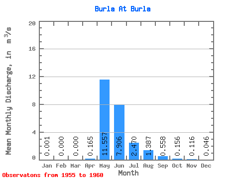
| Statistic | Jan | Feb | Mar | Apr | May | Jun | Jul | Aug | Sep | Oct | Nov | Dec | Annual |
|---|---|---|---|---|---|---|---|---|---|---|---|---|---|
| Mean | 0.00 | 0.00 | 0.00 | 0.17 | 11.56 | 7.91 | 2.47 | 1.39 | 0.56 | 0.16 | 0.12 | 0.05 | 1.38 |
| Standard Deviation | 0.00 | 0.00 | 0.00 | 0.16 | 16.75 | 11.54 | 4.79 | 2.61 | 0.86 | 0.21 | 0.19 | 0.09 | 2.34 |
| Min | 0.00 | 0.00 | 0.00 | 0.05 | 0.02 | 0.04 | 0.01 | 0.00 | 0.00 | 0.00 | 0.00 | 0.00 | 0.01 |
| Max | 0.01 | 0.00 | 0.00 | 0.43 | 37.60 | 25.50 | 12.20 | 6.67 | 2.26 | 0.47 | 0.44 | 0.21 | 4.87 |
| Coefficient of Variation | 2.45 | 0.95 | 1.45 | 1.46 | 1.94 | 1.88 | 1.54 | 1.35 | 1.65 | 2.00 | 1.70 |
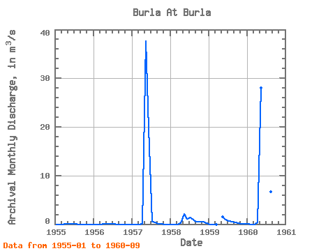
| Year | Jan | Feb | Mar | Apr | May | Jun | Jul | Aug | Sep | Oct | Nov | Dec | Annual | 1955 | 0.00 | 0.00 | 0.00 | 0.05 | 0.07 | 0.07 | 0.01 | 0.00 | 0.00 | 0.00 | 0.00 | 0.00 | 0.02 | 1956 | 0.00 | 0.00 | 0.00 | 0.06 | 0.02 | 0.04 | 0.01 | 0.00 | 0.00 | 0.00 | 0.00 | 0.00 | 0.01 | 1957 | 0.00 | 0.00 | 0.00 | 0.11 | 37.60 | 19.70 | 0.50 | 0.30 | 0.14 | 0.03 | 0.00 | 0.00 | 4.87 | 1958 | 0.00 | 0.00 | 0.00 | 0.17 | 2.09 | 1.14 | 1.42 | 0.84 | 0.53 | 0.47 | 0.44 | 0.21 | 0.61 | 1959 | 0.00 | 0.00 | 0.00 | 1.57 | 0.99 | 0.69 | 0.51 | 0.42 | 0.28 | 0.14 | 0.02 | 1960 | 0.01 | 0.00 | 0.00 | 0.43 | 28.00 | 25.50 | 12.20 | 6.67 | 2.26 |
|---|
 Return to R-Arctic Net Home Page