|
|
|||||||||||||||||
| Point ID: 8511 | Downloads | Plots | Site Data | Code: 10486 |
|
|
|||||||||||||||||
| Download | |
|---|---|
| Site Descriptor Information | Site Time Series Data |
| Link to all available data | |
|
|
| View: | Statistics | Time Series |
| Units: | mm |
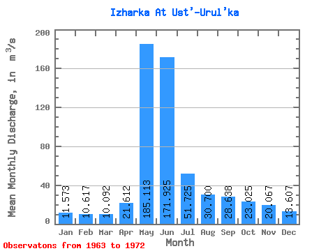
| Statistic | Jan | Feb | Mar | Apr | May | Jun | Jul | Aug | Sep | Oct | Nov | Dec | Annual |
|---|---|---|---|---|---|---|---|---|---|---|---|---|---|
| Mean | 11.57 | 10.62 | 10.09 | 21.61 | 185.11 | 171.93 | 51.73 | 30.70 | 28.64 | 23.02 | 20.07 | 13.61 | 48.12 |
| Standard Deviation | 3.46 | 3.04 | 1.67 | 9.65 | 89.11 | 111.08 | 59.92 | 17.19 | 13.45 | 6.74 | 8.41 | 3.92 | 20.16 |
| Min | 7.79 | 6.82 | 7.20 | 10.90 | 50.90 | 32.60 | 20.40 | 12.50 | 14.20 | 12.80 | 11.00 | 8.16 | 19.95 |
| Max | 19.60 | 17.30 | 12.50 | 37.50 | 297.00 | 304.00 | 198.00 | 63.30 | 49.30 | 30.60 | 38.40 | 19.60 | 73.00 |
| Coefficient of Variation | 0.30 | 0.29 | 0.17 | 0.45 | 0.48 | 0.65 | 1.16 | 0.56 | 0.47 | 0.29 | 0.42 | 0.29 | 0.42 |
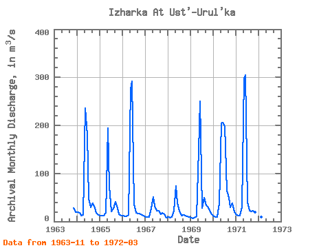
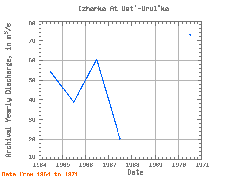
| Year | Jan | Feb | Mar | Apr | May | Jun | Jul | Aug | Sep | Oct | Nov | Dec | Annual | 1963 | 27.30 | 19.60 | 1964 | 19.60 | 17.30 | 12.50 | 13.20 | 236.00 | 180.00 | 47.50 | 29.70 | 38.20 | 28.00 | 17.90 | 14.00 | 54.49 | 1965 | 12.50 | 11.90 | 11.80 | 17.80 | 194.00 | 73.00 | 20.40 | 27.10 | 40.20 | 27.50 | 15.20 | 12.60 | 38.67 | 1966 | 11.70 | 10.50 | 10.40 | 13.00 | 276.00 | 292.00 | 36.80 | 18.40 | 16.70 | 15.90 | 14.20 | 11.90 | 60.62 | 1967 | 9.54 | 9.50 | 9.42 | 28.50 | 50.90 | 32.60 | 22.30 | 22.70 | 15.60 | 18.50 | 14.90 | 8.16 | 20.22 | 1968 | 8.63 | 8.12 | 9.06 | 21.60 | 74.00 | 37.80 | 20.70 | 12.50 | 14.20 | 12.80 | 11.00 | 9.00 | 19.95 | 1969 | 7.79 | 6.82 | 7.20 | 10.90 | 148.00 | 250.00 | 28.50 | 49.90 | 34.20 | 30.60 | 22.30 | 14.60 | 50.90 | 1970 | 10.50 | 9.69 | 9.85 | 37.50 | 205.00 | 206.00 | 198.00 | 63.30 | 49.30 | 29.20 | 38.40 | 19.20 | 73.00 | 1971 | 13.00 | 12.40 | 11.60 | 30.40 | 297.00 | 304.00 | 39.60 | 22.00 | 20.70 | 21.70 | 19.40 | 13.40 | 67.10 | 1972 | 10.90 | 9.32 | 9.00 |
|---|
 Return to R-Arctic Net Home Page