|
|
|||||||||||||||||
| Point ID: 8510 | Downloads | Plots | Site Data | Code: 10484 |
|
|
|||||||||||||||||
| Download | |
|---|---|
| Site Descriptor Information | Site Time Series Data |
| Link to all available data | |
|
|
| View: | Statistics | Time Series |
| Units: | mm |
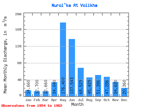
| Statistic | Jan | Feb | Mar | Apr | May | Jun | Jul | Aug | Sep | Oct | Nov | Dec | Annual |
|---|---|---|---|---|---|---|---|---|---|---|---|---|---|
| Mean | 14.66 | 12.70 | 12.66 | 34.04 | 176.40 | 137.54 | 68.53 | 45.43 | 51.39 | 47.29 | 34.62 | 20.36 | 59.32 |
| Standard Deviation | 2.52 | 1.01 | 1.80 | 14.51 | 20.86 | 38.08 | 45.82 | 18.95 | 18.43 | 15.13 | 15.31 | 6.31 | 9.89 |
| Min | 11.30 | 11.50 | 10.50 | 21.80 | 154.00 | 93.80 | 20.70 | 18.20 | 32.50 | 27.30 | 14.10 | 11.00 | 44.58 |
| Max | 18.30 | 14.10 | 15.30 | 58.80 | 201.00 | 185.00 | 132.00 | 70.60 | 86.20 | 72.00 | 53.20 | 25.40 | 65.84 |
| Coefficient of Variation | 0.17 | 0.08 | 0.14 | 0.43 | 0.12 | 0.28 | 0.67 | 0.42 | 0.36 | 0.32 | 0.44 | 0.31 | 0.17 |
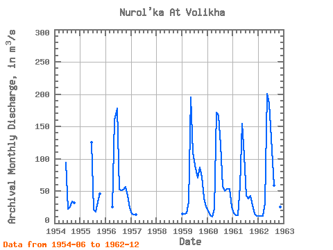
| Year | Jan | Feb | Mar | Apr | May | Jun | Jul | Aug | Sep | Oct | Nov | Dec | Annual | 1954 | 93.80 | 22.10 | 25.00 | 34.40 | 31.90 | 1955 | 125.00 | 20.70 | 18.20 | 32.50 | 45.20 | 1956 | 25.60 | 160.00 | 178.00 | 51.70 | 51.60 | 52.50 | 56.20 | 42.20 | 23.70 | 1957 | 14.40 | 13.10 | 13.10 | 1959 | 14.00 | 14.10 | 15.30 | 32.30 | 195.00 | 109.00 | 89.30 | 70.60 | 86.20 | 72.00 | 38.80 | 25.40 | 63.50 | 1960 | 18.30 | 12.00 | 10.50 | 21.80 | 172.00 | 167.00 | 121.00 | 56.10 | 50.10 | 53.40 | 53.20 | 25.00 | 63.37 | 1961 | 15.30 | 12.80 | 12.80 | 58.80 | 154.00 | 105.00 | 42.90 | 38.40 | 42.60 | 27.30 | 14.10 | 11.00 | 44.58 | 1962 | 11.30 | 11.50 | 11.60 | 31.70 | 201.00 | 185.00 | 132.00 | 58.10 | 61.40 | 45.00 | 24.80 | 16.70 | 65.84 |
|---|
 Return to R-Arctic Net Home Page