|
|
|||||||||||||||||
| Point ID: 8498 | Downloads | Plots | Site Data | Code: 10410 |
|
|
|||||||||||||||||
| Download | |
|---|---|
| Site Descriptor Information | Site Time Series Data |
| Link to all available data | |
|
|
| View: | Statistics | Time Series |
| Units: | mm |
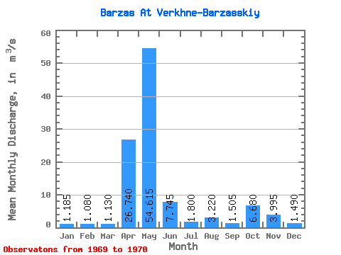
| Statistic | Jan | Feb | Mar | Apr | May | Jun | Jul | Aug | Sep | Oct | Nov | Dec | Annual |
|---|---|---|---|---|---|---|---|---|---|---|---|---|---|
| Mean | 1.19 | 1.08 | 1.13 | 26.74 | 54.62 | 7.75 | 1.80 | 3.22 | 1.50 | 6.68 | 4.00 | 1.49 | 9.27 |
| Standard Deviation | 0.32 | 0.06 | 0.17 | 26.95 | 76.91 | 2.65 | 0.55 | 0.57 | 0.53 | 4.13 | 0.77 | 0.31 | 4.72 |
| Min | 0.96 | 1.04 | 1.01 | 7.68 | 0.23 | 5.87 | 1.41 | 2.82 | 1.13 | 3.76 | 3.45 | 1.27 | 5.92 |
| Max | 1.41 | 1.12 | 1.25 | 45.80 | 109.00 | 9.62 | 2.19 | 3.62 | 1.88 | 9.60 | 4.54 | 1.71 | 12.61 |
| Coefficient of Variation | 0.27 | 0.05 | 0.15 | 1.01 | 1.41 | 0.34 | 0.31 | 0.18 | 0.35 | 0.62 | 0.19 | 0.21 | 0.51 |
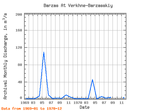
| Year | Jan | Feb | Mar | Apr | May | Jun | Jul | Aug | Sep | Oct | Nov | Dec | Annual | 1969 | 1.41 | 1.04 | 1.01 | 7.68 | 109.00 | 9.62 | 1.41 | 2.82 | 1.88 | 9.60 | 4.54 | 1.27 | 12.61 | 1970 | 0.96 | 1.12 | 1.25 | 45.80 | 0.23 | 5.87 | 2.19 | 3.62 | 1.13 | 3.76 | 3.45 | 1.71 | 5.92 |
|---|
 Return to R-Arctic Net Home Page