|
|
|||||||||||||||||
| Point ID: 8468 | Downloads | Plots | Site Data | Code: 10262 |
|
|
|||||||||||||||||
| Download | |
|---|---|
| Site Descriptor Information | Site Time Series Data |
| Link to all available data | |
|
|
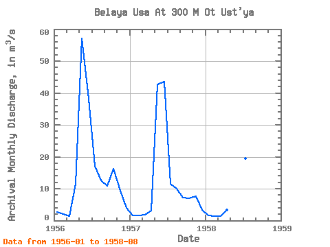
| View: | Statistics | Time Series |
| Units: | mm |
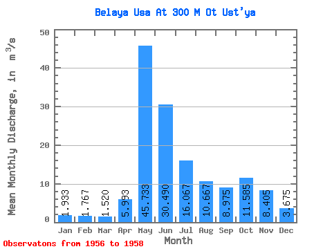
| Statistic | Jan | Feb | Mar | Apr | May | Jun | Jul | Aug | Sep | Oct | Nov | Dec | Annual |
|---|---|---|---|---|---|---|---|---|---|---|---|---|---|
| Mean | 1.93 | 1.77 | 1.52 | 5.99 | 45.73 | 30.49 | 16.07 | 10.67 | 8.97 | 11.59 | 8.40 | 3.67 | 13.49 |
| Standard Deviation | 0.58 | 0.33 | 0.30 | 4.69 | 10.10 | 18.14 | 4.02 | 1.69 | 2.58 | 6.53 | 1.22 | 0.56 | 2.47 |
| Min | 1.56 | 1.48 | 1.32 | 3.14 | 37.50 | 9.77 | 11.60 | 9.50 | 7.15 | 6.97 | 7.54 | 3.28 | 11.74 |
| Max | 2.60 | 2.12 | 1.86 | 11.40 | 57.00 | 43.50 | 19.40 | 12.60 | 10.80 | 16.20 | 9.27 | 4.07 | 15.23 |
| Coefficient of Variation | 0.30 | 0.18 | 0.20 | 0.78 | 0.22 | 0.59 | 0.25 | 0.16 | 0.29 | 0.56 | 0.14 | 0.15 | 0.18 |
| Year | Jan | Feb | Mar | Apr | May | Jun | Jul | Aug | Sep | Oct | Nov | Dec | Annual | 1956 | 2.60 | 2.12 | 1.32 | 11.40 | 57.00 | 38.20 | 17.20 | 12.60 | 10.80 | 16.20 | 9.27 | 4.07 | 15.23 | 1957 | 1.56 | 1.70 | 1.86 | 3.14 | 42.70 | 43.50 | 11.60 | 9.90 | 7.15 | 6.97 | 7.54 | 3.28 | 11.74 | 1958 | 1.64 | 1.48 | 1.38 | 3.44 | 37.50 | 9.77 | 19.40 | 9.50 |
|---|
 Return to R-Arctic Net Home Page