|
|
|||||||||||||||||
| Point ID: 8466 | Downloads | Plots | Site Data | Code: 10260 |
|
|
|||||||||||||||||
| Download | |
|---|---|
| Site Descriptor Information | Site Time Series Data |
| Link to all available data | |
|
|
| View: | Statistics | Time Series |
| Units: | mm |
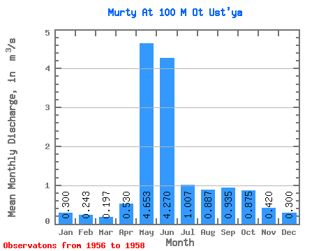
| Statistic | Jan | Feb | Mar | Apr | May | Jun | Jul | Aug | Sep | Oct | Nov | Dec | Annual |
|---|---|---|---|---|---|---|---|---|---|---|---|---|---|
| Mean | 0.30 | 0.24 | 0.20 | 0.53 | 4.65 | 4.27 | 1.01 | 0.89 | 0.94 | 0.88 | 0.42 | 0.30 | 0.98 |
| Standard Deviation | 0.08 | 0.06 | 0.05 | 0.11 | 0.54 | 3.95 | 0.76 | 0.17 | 0.53 | 0.45 | 0.10 | 0.04 | 0.15 |
| Min | 0.21 | 0.17 | 0.14 | 0.46 | 4.05 | 1.86 | 0.54 | 0.78 | 0.56 | 0.56 | 0.35 | 0.27 | 0.87 |
| Max | 0.36 | 0.28 | 0.23 | 0.66 | 5.08 | 8.83 | 1.88 | 1.08 | 1.31 | 1.19 | 0.49 | 0.33 | 1.08 |
| Coefficient of Variation | 0.27 | 0.26 | 0.25 | 0.21 | 0.12 | 0.93 | 0.75 | 0.19 | 0.57 | 0.51 | 0.24 | 0.14 | 0.16 |
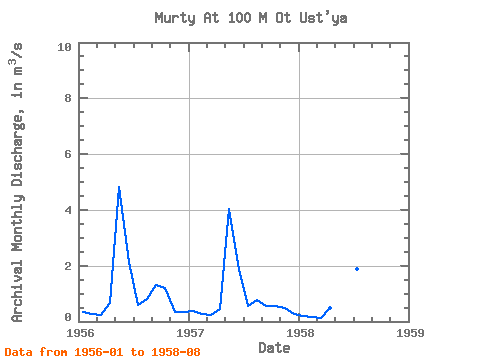
| Year | Jan | Feb | Mar | Apr | May | Jun | Jul | Aug | Sep | Oct | Nov | Dec | Annual | 1956 | 0.33 | 0.28 | 0.22 | 0.66 | 4.83 | 2.12 | 0.60 | 0.80 | 1.31 | 1.19 | 0.35 | 0.33 | 1.08 | 1957 | 0.36 | 0.28 | 0.23 | 0.46 | 4.05 | 1.86 | 0.54 | 0.78 | 0.56 | 0.56 | 0.49 | 0.27 | 0.87 | 1958 | 0.21 | 0.17 | 0.14 | 0.47 | 5.08 | 8.83 | 1.88 | 1.08 |
|---|
 Return to R-Arctic Net Home Page