|
|
|||||||||||||||||
| Point ID: 8437 | Downloads | Plots | Site Data | Code: 10125 |
|
|
|||||||||||||||||
| Download | |
|---|---|
| Site Descriptor Information | Site Time Series Data |
| Link to all available data | |
|
|
| View: | Statistics | Time Series |
| Units: | mm |
| Statistic | Jan | Feb | Mar | Apr | May | Jun | Jul | Aug | Sep | Oct | Nov | Dec | Annual |
|---|---|---|---|---|---|---|---|---|---|---|---|---|---|
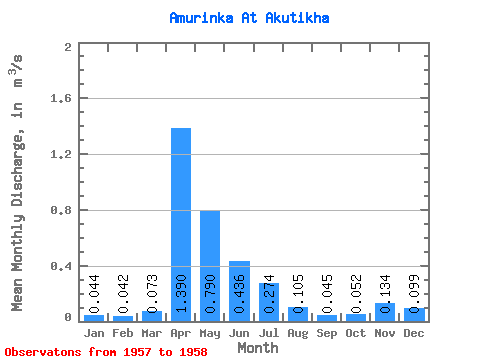
| Mean | 0.04 | 0.04 | 0.07 | 1.39 | 0.79 | 0.44 | 0.27 | 0.10 | 0.04 | 0.05 | 0.13 | 0.10 | 0.29 |
| Standard Deviation | 0.04 | 0.03 | 0.03 | 1.10 | 0.33 | 0.52 | 0.33 | 0.11 | 0.02 | 0.03 | 0.18 | 0.00 | 0.19 |
| Min | 0.02 | 0.03 | 0.05 | 0.61 | 0.56 | 0.07 | 0.04 | 0.03 | 0.03 | 0.03 | 0.01 | 0.10 | 0.15 |
| Max | 0.07 | 0.06 | 0.09 | 2.17 | 1.02 | 0.80 | 0.51 | 0.18 | 0.06 | 0.07 | 0.26 | 0.10 | 0.42 |
| Coefficient of Variation | 0.92 | 0.59 | 0.41 | 0.79 | 0.41 | 1.18 | 1.22 | 1.01 | 0.47 | 0.51 | 1.32 | 0.01 | 0.66 |
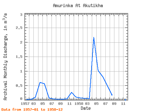
| Year | Jan | Feb | Mar | Apr | May | Jun | Jul | Aug | Sep | Oct | Nov | Dec | Annual | 1957 | 0.02 | 0.03 | 0.09 | 0.61 | 0.56 | 0.07 | 0.04 | 0.03 | 0.03 | 0.03 | 0.26 | 0.10 | 0.15 | 1958 | 0.07 | 0.06 | 0.05 | 2.17 | 1.02 | 0.80 | 0.51 | 0.18 | 0.06 | 0.07 | 0.01 | 0.10 | 0.42 |
|---|
 Return to R-Arctic Net Home Page