|
|
|||||||||||||||||
| Point ID: 8436 | Downloads | Plots | Site Data | Code: 10124 |
|
|
|||||||||||||||||
| Download | |
|---|---|
| Site Descriptor Information | Site Time Series Data |
| Link to all available data | |
|
|
| View: | Statistics | Time Series |
| Units: | mm |
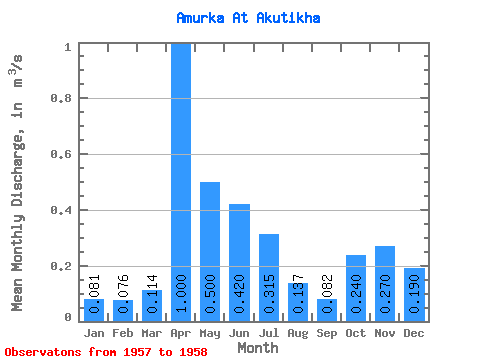
| Statistic | Jan | Feb | Mar | Apr | May | Jun | Jul | Aug | Sep | Oct | Nov | Dec | Annual |
|---|---|---|---|---|---|---|---|---|---|---|---|---|---|
| Mean | 0.08 | 0.08 | 0.11 | 1.00 | 0.50 | 0.42 | 0.32 | 0.14 | 0.08 | 0.24 | 0.27 | 0.19 | 0.28 |
| Standard Deviation | 0.07 | 0.05 | 0.04 | 0.61 | 0.27 | 0.35 | 0.36 | 0.12 | 0.04 | 0.17 | 0.14 | 0.13 | 0.19 |
| Min | 0.03 | 0.04 | 0.09 | 0.57 | 0.31 | 0.17 | 0.06 | 0.05 | 0.05 | 0.12 | 0.17 | 0.10 | 0.15 |
| Max | 0.13 | 0.11 | 0.14 | 1.43 | 0.69 | 0.67 | 0.57 | 0.22 | 0.11 | 0.36 | 0.37 | 0.28 | 0.42 |
| Coefficient of Variation | 0.84 | 0.65 | 0.32 | 0.61 | 0.54 | 0.84 | 1.15 | 0.86 | 0.48 | 0.71 | 0.53 | 0.67 | 0.66 |
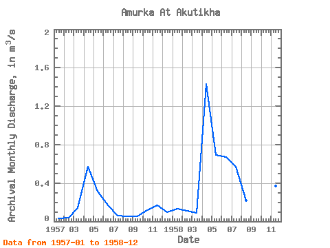
| Year | Jan | Feb | Mar | Apr | May | Jun | Jul | Aug | Sep | Oct | Nov | Dec | Annual | 1957 | 0.03 | 0.04 | 0.14 | 0.57 | 0.31 | 0.17 | 0.06 | 0.05 | 0.05 | 0.12 | 0.17 | 0.10 | 0.15 | 1958 | 0.13 | 0.11 | 0.09 | 1.43 | 0.69 | 0.67 | 0.57 | 0.22 | 0.11 | 0.36 | 0.37 | 0.28 | 0.42 |
|---|
 Return to R-Arctic Net Home Page