|
|
|||||||||||||||||
| Point ID: 8426 | Downloads | Plots | Site Data | Code: 10096 |
|
|
|||||||||||||||||
| Download | |
|---|---|
| Site Descriptor Information | Site Time Series Data |
| Link to all available data | |
|
|
| View: | Statistics | Time Series |
| Units: | mm |
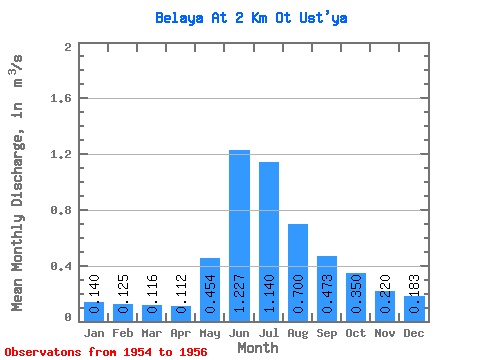
| Statistic | Jan | Feb | Mar | Apr | May | Jun | Jul | Aug | Sep | Oct | Nov | Dec | Annual |
|---|---|---|---|---|---|---|---|---|---|---|---|---|---|
| Mean | 0.14 | 0.12 | 0.12 | 0.11 | 0.45 | 1.23 | 1.14 | 0.70 | 0.47 | 0.35 | 0.22 | 0.18 | 0.44 |
| Standard Deviation | 0.04 | 0.04 | 0.04 | 0.03 | 0.37 | 0.54 | 0.80 | 0.30 | 0.18 | 0.16 | 0.07 | 0.05 | 0.20 |
| Min | 0.11 | 0.08 | 0.08 | 0.09 | 0.08 | 0.89 | 0.64 | 0.43 | 0.28 | 0.17 | 0.14 | 0.13 | 0.27 |
| Max | 0.18 | 0.17 | 0.16 | 0.15 | 0.83 | 1.85 | 2.06 | 1.03 | 0.63 | 0.48 | 0.28 | 0.21 | 0.67 |
| Coefficient of Variation | 0.26 | 0.35 | 0.35 | 0.30 | 0.82 | 0.44 | 0.70 | 0.43 | 0.38 | 0.46 | 0.33 | 0.25 | 0.47 |
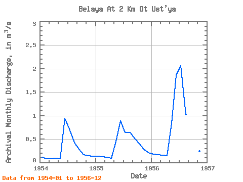
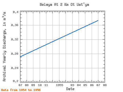
| Year | Jan | Feb | Mar | Apr | May | Jun | Jul | Aug | Sep | Oct | Nov | Dec | Annual | 1954 | 0.11 | 0.08 | 0.08 | 0.09 | 0.08 | 0.94 | 0.72 | 0.43 | 0.28 | 0.17 | 0.14 | 0.13 | 0.27 | 1955 | 0.13 | 0.12 | 0.11 | 0.09 | 0.45 | 0.89 | 0.64 | 0.64 | 0.51 | 0.40 | 0.28 | 0.21 | 0.37 | 1956 | 0.18 | 0.17 | 0.16 | 0.15 | 0.83 | 1.85 | 2.06 | 1.03 | 0.63 | 0.48 | 0.24 | 0.21 | 0.67 |
|---|
 Return to R-Arctic Net Home Page