|
|
|||||||||||||||||
| Point ID: 8421 | Downloads | Plots | Site Data | Code: 10080 |
|
|
|||||||||||||||||
| Download | |
|---|---|
| Site Descriptor Information | Site Time Series Data |
| Link to all available data | |
|
|
| View: | Statistics | Time Series |
| Units: | mm |
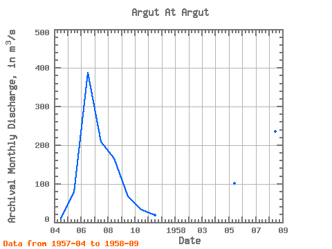
| Statistic | Jan | Feb | Mar | Apr | May | Jun | Jul | Aug | Sep | Oct | Nov | Dec | Annual |
|---|---|---|---|---|---|---|---|---|---|---|---|---|---|
| Mean | 10.70 | 90.25 | 349.00 | 312.50 | 201.00 | 93.55 | 33.90 | 18.40 | |||||
| Standard Deviation | 16.62 | 55.15 | 147.78 | 49.50 | 37.41 | ||||||||
| Min | 10.70 | 78.50 | 310.00 | 208.00 | 166.00 | 67.10 | 33.90 | 18.40 | |||||
| Max | 10.70 | 102.00 | 388.00 | 417.00 | 236.00 | 120.00 | 33.90 | 18.40 | |||||
| Coefficient of Variation | 0.18 | 0.16 | 0.47 | 0.25 | 0.40 |
| Year | Jan | Feb | Mar | Apr | May | Jun | Jul | Aug | Sep | Oct | Nov | Dec | Annual | 1957 | 10.70 | 78.50 | 388.00 | 208.00 | 166.00 | 67.10 | 33.90 | 18.40 | 1958 | 102.00 | 310.00 | 417.00 | 236.00 | 120.00 |
|---|
 Return to R-Arctic Net Home Page
