|
|
|||||||||||||||||
| Point ID: 8390 | Downloads | Plots | Site Data | Code: 9480 |
|
|
|||||||||||||||||
| Download | |
|---|---|
| Site Descriptor Information | Site Time Series Data |
| Link to all available data | |
|
|
| View: | Statistics | Time Series |
| Units: | mm |
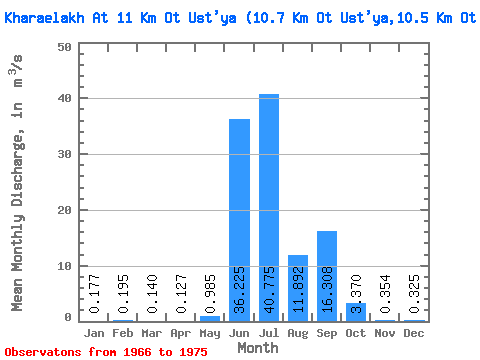
| Statistic | Jan | Feb | Mar | Apr | May | Jun | Jul | Aug | Sep | Oct | Nov | Dec | Annual |
|---|---|---|---|---|---|---|---|---|---|---|---|---|---|
| Mean | 0.18 | 0.20 | 0.14 | 0.13 | 0.98 | 36.23 | 40.77 | 11.89 | 16.31 | 3.37 | 0.35 | 0.33 | 9.23 |
| Standard Deviation | 0.12 | 0.15 | 0.11 | 0.10 | 0.78 | 25.46 | 27.90 | 10.46 | 5.52 | 4.71 | 0.20 | 0.30 | 1.54 |
| Min | 0.00 | 0.00 | 0.00 | 0.00 | 0.23 | 13.10 | 17.30 | 2.62 | 9.93 | 0.56 | 0.16 | 0.10 | 7.13 |
| Max | 0.29 | 0.33 | 0.24 | 0.21 | 1.74 | 65.70 | 74.30 | 25.40 | 23.10 | 10.40 | 0.65 | 0.86 | 10.54 |
| Coefficient of Variation | 0.71 | 0.80 | 0.78 | 0.78 | 0.79 | 0.70 | 0.68 | 0.88 | 0.34 | 1.40 | 0.56 | 0.94 | 0.17 |
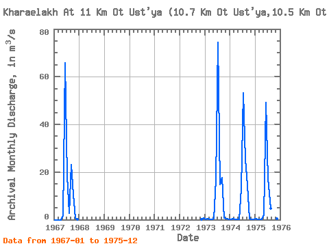
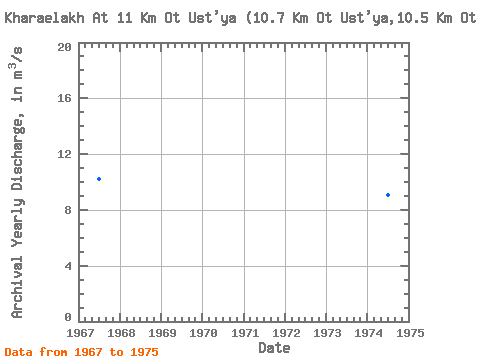
| Year | Jan | Feb | Mar | Apr | May | Jun | Jul | Aug | Sep | Oct | Nov | Dec | Annual | 1966 | 1967 | 0.00 | 0.00 | 0.00 | 0.00 | 1.57 | 65.70 | 18.30 | 2.62 | 23.10 | 10.40 | 0.65 | 0.20 | 10.21 | 1972 | 0.16 | 0.86 | 1973 | 0.19 | 0.31 | 0.24 | 0.21 | 0.40 | 16.90 | 74.30 | 14.80 | 17.60 | 0.84 | 0.45 | 0.27 | 10.54 | 1974 | 0.23 | 0.33 | 0.21 | 0.20 | 0.23 | 13.10 | 53.20 | 25.40 | 14.60 | 0.56 | 0.22 | 0.20 | 9.04 | 1975 | 0.29 | 0.14 | 0.11 | 0.10 | 1.74 | 49.20 | 17.30 | 4.75 | 9.93 | 1.68 | 0.29 | 0.10 | 7.13 |
|---|
 Return to R-Arctic Net Home Page