|
|
|||||||||||||||||
| Point ID: 8374 | Downloads | Plots | Site Data | Code: 9436 |
|
|
|||||||||||||||||
| Download | |
|---|---|
| Site Descriptor Information | Site Time Series Data |
| Link to all available data | |
|
|
| View: | Statistics | Time Series |
| Units: | mm |
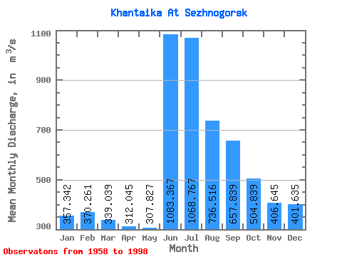
| Statistic | Jan | Feb | Mar | Apr | May | Jun | Jul | Aug | Sep | Oct | Nov | Dec | Annual |
|---|---|---|---|---|---|---|---|---|---|---|---|---|---|
| Mean | 357.34 | 370.26 | 339.04 | 312.05 | 307.83 | 1083.37 | 1068.77 | 736.52 | 657.84 | 504.84 | 406.64 | 401.63 | 549.33 |
| Standard Deviation | 267.29 | 296.61 | 276.13 | 254.58 | 193.17 | 986.13 | 777.38 | 341.98 | 205.77 | 160.63 | 238.24 | 258.94 | 109.26 |
| Min | 36.40 | 19.60 | 12.10 | 10.80 | 37.00 | 252.00 | 122.00 | 216.00 | 322.00 | 158.00 | 120.00 | 67.20 | 275.27 |
| Max | 779.00 | 924.00 | 885.00 | 706.00 | 668.00 | 3060.00 | 3360.00 | 1840.00 | 1190.00 | 814.00 | 899.00 | 862.00 | 821.75 |
| Coefficient of Variation | 0.75 | 0.80 | 0.81 | 0.82 | 0.63 | 0.91 | 0.73 | 0.46 | 0.31 | 0.32 | 0.59 | 0.65 | 0.20 |
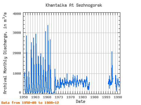
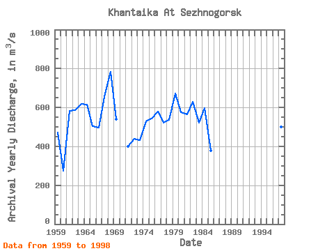
| Year | Jan | Feb | Mar | Apr | May | Jun | Jul | Aug | Sep | Oct | Nov | Dec | Annual | 1958 | 888.00 | 1070.00 | 340.00 | 120.00 | 100.00 | 1959 | 64.00 | 44.80 | 41.30 | 41.50 | 40.60 | 2850.00 | 1210.00 | 480.00 | 378.00 | 286.00 | 128.00 | 97.00 | 471.77 | 1960 | 61.70 | 34.60 | 21.30 | 17.20 | 465.00 | 1080.00 | 511.00 | 401.00 | 322.00 | 158.00 | 142.00 | 89.40 | 275.27 | 1961 | 65.50 | 52.50 | 44.10 | 43.80 | 66.10 | 1810.00 | 2510.00 | 999.00 | 730.00 | 362.00 | 206.00 | 109.00 | 583.17 | 1962 | 69.30 | 56.30 | 49.60 | 44.60 | 48.00 | 2750.00 | 1990.00 | 871.00 | 581.00 | 296.00 | 167.00 | 119.00 | 586.82 | 1963 | 79.00 | 48.80 | 43.70 | 39.10 | 37.00 | 2930.00 | 2000.00 | 907.00 | 640.00 | 404.00 | 171.00 | 112.00 | 617.63 | 1964 | 74.60 | 58.00 | 45.30 | 43.60 | 147.00 | 1860.00 | 1770.00 | 1160.00 | 1190.00 | 599.00 | 284.00 | 159.00 | 615.88 | 1965 | 98.90 | 68.30 | 52.60 | 47.50 | 79.00 | 1700.00 | 1970.00 | 834.00 | 539.00 | 421.00 | 149.00 | 91.10 | 504.20 | 1966 | 64.40 | 45.30 | 28.20 | 22.30 | 37.10 | 1790.00 | 1480.00 | 865.00 | 816.00 | 414.00 | 250.00 | 148.00 | 496.69 | 1967 | 109.00 | 83.70 | 69.60 | 69.20 | 294.00 | 3060.00 | 1530.00 | 649.00 | 601.00 | 814.00 | 324.00 | 238.00 | 653.46 | 1968 | 151.00 | 101.00 | 77.30 | 62.10 | 69.80 | 2160.00 | 3360.00 | 1840.00 | 990.00 | 368.00 | 166.00 | 67.20 | 784.37 | 1969 | 36.40 | 19.60 | 12.10 | 10.80 | 130.00 | 2660.00 | 1450.00 | 929.00 | 656.00 | 302.00 | 146.00 | 118.00 | 539.16 | 1970 | 78.90 | 54.10 | 36.10 | 23.20 | 1971 | 62.90 | 71.10 | 64.00 | 62.50 | 50.20 | 1210.00 | 891.00 | 764.00 | 671.00 | 570.00 | 174.00 | 213.00 | 400.31 | 1972 | 295.00 | 344.00 | 334.00 | 376.00 | 383.00 | 308.00 | 688.00 | 686.00 | 627.00 | 515.00 | 337.00 | 369.00 | 438.50 | 1973 | 331.00 | 286.00 | 300.00 | 236.00 | 297.00 | 323.00 | 599.00 | 667.00 | 776.00 | 594.00 | 311.00 | 470.00 | 432.50 | 1974 | 312.00 | 570.00 | 473.00 | 453.00 | 518.00 | 491.00 | 612.00 | 681.00 | 706.00 | 610.00 | 485.00 | 436.00 | 528.92 | 1975 | 426.00 | 503.00 | 503.00 | 510.00 | 427.00 | 293.00 | 720.00 | 786.00 | 746.00 | 603.00 | 446.00 | 542.00 | 542.08 | 1976 | 544.00 | 587.00 | 563.00 | 490.00 | 494.00 | 414.00 | 975.00 | 651.00 | 596.00 | 569.00 | 512.00 | 532.00 | 577.25 | 1977 | 497.00 | 560.00 | 558.00 | 411.00 | 353.00 | 341.00 | 524.00 | 566.00 | 632.00 | 673.00 | 520.00 | 637.00 | 522.67 | 1978 | 611.00 | 518.00 | 462.00 | 461.00 | 461.00 | 417.00 | 627.00 | 628.00 | 551.00 | 587.00 | 519.00 | 602.00 | 537.00 | 1979 | 680.00 | 924.00 | 757.00 | 697.00 | 592.00 | 360.00 | 479.00 | 643.00 | 567.00 | 658.00 | 834.00 | 862.00 | 671.08 | 1980 | 733.00 | 657.00 | 635.00 | 532.00 | 327.00 | 320.00 | 372.00 | 555.00 | 636.00 | 595.00 | 899.00 | 624.00 | 573.75 | 1981 | 623.00 | 658.00 | 534.00 | 532.00 | 383.00 | 500.00 | 514.00 | 521.00 | 522.00 | 639.00 | 699.00 | 643.00 | 564.00 | 1982 | 685.00 | 634.00 | 688.00 | 585.00 | 536.00 | 466.00 | 624.00 | 642.00 | 593.00 | 703.00 | 726.00 | 687.00 | 630.75 | 1983 | 636.00 | 606.00 | 467.00 | 606.00 | 405.00 | 343.00 | 473.00 | 337.00 | 457.00 | 625.00 | 590.00 | 698.00 | 520.25 | 1984 | 679.00 | 624.00 | 574.00 | 688.00 | 379.00 | 333.00 | 413.00 | 616.00 | 579.00 | 608.00 | 855.00 | 824.00 | 597.67 | 1985 | 779.00 | 470.00 | 428.00 | 306.00 | 209.00 | 252.00 | 363.00 | 216.00 | 479.00 | 199.00 | 305.00 | 532.00 | 378.17 | 1994 | 496.00 | 590.00 | 501.00 | 706.00 | 668.00 | 259.00 | 879.00 | 654.00 | 637.00 | 678.00 | 412.00 | 437.00 | 576.42 | 1995 | 485.00 | 548.00 | 593.00 | 460.00 | 445.00 | 466.00 | 2070.00 | 1650.00 | 1150.00 | 565.00 | 684.00 | 745.00 | 821.75 | 1997 | 504.00 | 907.00 | 885.00 | 631.00 | 394.00 | 258.00 | 122.00 | 290.00 | 437.00 | 498.00 | 462.00 | 619.00 | 500.58 | 1998 | 746.00 | 754.00 | 670.00 | 466.00 | 500.00 | 497.00 | 337.00 | 456.00 | 518.00 | 397.00 | 583.00 | 531.00 | 537.92 |
|---|
 Return to R-Arctic Net Home Page